Latitude: 52.1664 / 52°9'59"N
Longitude: 0.7124 / 0°42'44"E
OS Eastings: 585602
OS Northings: 255487
OS Grid: TL856554
Mapcode National: GBR QFZ.0YB
Mapcode Global: VHKDJ.9TH2
Plus Code: 9F425P86+HX
Entry Name: Hills Farmhouse
Listing Date: 9 February 1978
Grade: II
Source: Historic England
Source ID: 1181396
English Heritage Legacy ID: 278082
ID on this website: 101181396
Location: Lawshall, Babergh, Suffolk, IP29
County: Suffolk
District: Babergh
Civil Parish: Lawshall
Traditional County: Suffolk
Lieutenancy Area (Ceremonial County): Suffolk
Church of England Parish: Lawshall All Saints
Church of England Diocese: St.Edmundsbury and Ipswich
Tagged with: Farmhouse
LAWSHALL
922/2/290 BURY ROAD
09-FEB-78 HILLS FARMHOUSE
II
Dwelling of C16 with C17, C18 and C20 alterations, two storeys and attics with a central chimney stack.
MATERIALS
Timber framed and plastered with a thatched gable roof.
PLAN
Rectangular.
EXTERIOR
The west elevation has an off-centre external brick stack, probably of C18 date, and a small out-shot at the ground floor. There are C20 casements to the first and attic floors. The north elevation has a brick plinth of C16 date but is otherwise plain with C20 casements to the ground and first floors. The east elevation has a late C20 single storey extension with tile-covered pent roof. The gable above has weatherboard cladding and C20 casements at first and attic floors. The south elevation has a single storey extension with tile covered gable roof and weatherboard cladding. At the east end is a diamond mullion window with applied fillets.
INTERIOR
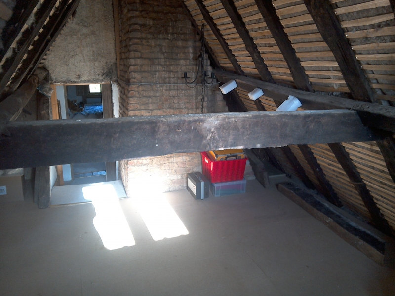
The ground floor has a two room plan. Both rooms have close studded walls, intact sole plate and midrails, and substantial wall posts, some jowled. The floor frames have transverse chamfered and stopped bridging beams. Some of the framing has been ruddled. A large C17 stack has been inserted, with an inglenook fireplace in the east room with a substantial bressumer, bread oven and possible curing oven. The north wall frame has two blocked door openings which may be later, and there is a central entrance on the south wall frame. The latter may be the entrance to a screens passage.There are a number of exposed diamond mullion window openings, some with shutter grooves, and there is a former stair opening in the floor frame of the west room. A C20 stair to the left of the stack leads to the first floor where two tie beams with cranked arch bracing are evident. All rooms have intact wall framing including the wall plate and studwork. However, the position of the base of the rafters suggests that the roof pitch has been altered. The axial bridging beam of thinner scantling is C18. The roof structure comprises coupled common rafters with collars and clasped purlins. It is suggested that some of the rafters are smoke-blackened. The west gable end framing has been replaced.
HISTORY
The building is represented on a map of the village of Lawshall dated 1611 and referred to in documentary sources of 1547 and 1567 as a freehold farmhouse called 'Hille's'. The earliest building is thought to be a two-bay dwelling with a screens passage, the roof structure and passage of which was adapted following the insertion of a chimney probably in the C17. Other interior remodelling occurred at the same time, including the insertion of an internal staircase next to the stack. In the C18 a second floor was inserted in the roof to create an attic and a half-hip was replaced with a gable at the west elevation. There are C20 additions to the east and south.
REASONS FOR DESIGNATION
Hills Farmhouse, Bury Road, Lawshall is designated at Grade II for the following principal reasons:
* It is a building of the C16 or earlier which retains a significant proportion of the original fabric and important interior features of the C16 and C17.
* It displays the evolution of vernacular building forms from the medieval to post-medieval period.
* The building is mentioned in documents of the C16 and depicted in cartographic evidence of the early C17.
Listing NGR: TL8560155488
External links are from the relevant listing authority and, where applicable, Wikidata. Wikidata IDs may be related buildings as well as this specific building. If you want to add or update a link, you will need to do so by editing the Wikidata entry.


Other nearby listed buildings