Latitude: 51.6778 / 51°40'40"N
Longitude: -1.6682 / 1°40'5"W
OS Eastings: 423041
OS Northings: 197720
OS Grid: SU230977
Mapcode National: GBR 5VC.R24
Mapcode Global: VHC0K.13G4
Plus Code: 9C3WM8HJ+4P
Entry Name: Manor Farmhouse
Listing Date: 10 November 1952
Grade: II*
Source: Historic England
Source ID: 1181672
English Heritage Legacy ID: 251473
ID on this website: 101181672
Location: Buscot, Vale of White Horse, Oxfordshire, SN7
County: Oxfordshire
District: Vale of White Horse
Civil Parish: Buscot
Traditional County: Berkshire
Lieutenancy Area (Ceremonial County): Oxfordshire
Church of England Parish: Buscot
Church of England Diocese: Oxford
Tagged with: Farmhouse
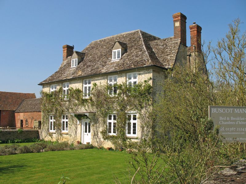
BUSCOT THE STREET (West side) SU2397 Manor Farmhouse 5/15 10/11/52 GV II* Farmhouse. 1691 as recorded on datestone formerly on E wall recently disintegrated. Coursed rubble stone with dressed stone quotas, moulded eaves and a hipped stone tiled roof. 2 storeys and attic. S front of 5 bays, the outer bays spaced close together. 2 stone tiled, gabled dormers with 2-light casements, 4-light wood mullioned and transomed leaded lights and a modern part-glazed door in moulded stone architrave with a plain moulded hood supported by ornately carved brackets. N front has similar fenestration and a rear door with plain flat hood and less ornate carved consoles. 2 one-storey C20 additions to E and W. The interior has a contemporary staircase with a plain elm handrail and turned balusters, 3 wooden fireplaces with bolection friezes and several cornices of stylised foliage.
Listing NGR: SU2304197720
External links are from the relevant listing authority and, where applicable, Wikidata. Wikidata IDs may be related buildings as well as this specific building. If you want to add or update a link, you will need to do so by editing the Wikidata entry.


Other nearby listed buildings