Latitude: 51.7557 / 51°45'20"N
Longitude: 0.0237 / 0°1'25"E
OS Eastings: 539776
OS Northings: 208271
OS Grid: TL397082
Mapcode National: GBR LDL.SZ8
Mapcode Global: VHHMC.C4DF
Plus Code: 9F32Q24F+7F
Entry Name: Netherhall
Listing Date: 4 July 1984
Grade: I
Source: Historic England
Source ID: 1182255
English Heritage Legacy ID: 118821
ID on this website: 101182255
Location: Epping Forest, Essex, CM19
County: Essex
District: Epping Forest
Civil Parish: Roydon
Built-Up Area: Hoddesdon
Traditional County: Essex
Lieutenancy Area (Ceremonial County): Essex
Church of England Parish: Roydon St Peter
Church of England Diocese: Chelmsford
Tagged with: Fortified house Gatehouse
TL 30 NE ROYDON NETHERHALL ROAD
2/1 Netherhall
GV I
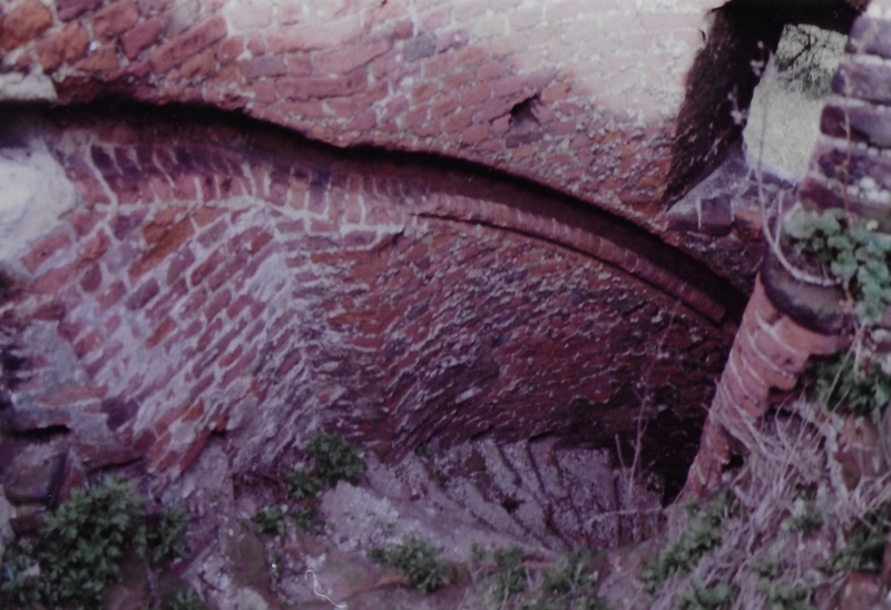
Ruined gatehouse, to fortified house now mostly demolished. Mid C15 in red
brick, with diapering in white brick and flared headers. 2 semi-octagonal
towers with gateway between. 3 storeys. Trefoiled corbelled parapets. To
the rear of the former right hand tower, is a further semi-octagonal projection
rising to full height of the building, and behind this a staircase tower. Outer
face of left hand tower has cruciform loops to ground floor, and windows with
four centred heads and square labels. Right hand side has square headed
windows, and is surmounted by 2 chimney shafts of spirally moulded brick with
moulded caps and bases. Between the 2 towers is the original outer arch of
the gateway, with moulded stone jambs and 4 centred arch in a square head.
Above are the remains of a square headed window of stone. Part of the curtain
wall to the right survives, bur on remaining sides is represented by foundations
only. Lower part of north west angle tower survives, with cruciform loops in
each face. Foundation mounds of domestic buildings are traceable within the
walls. Internally, the left hand side of the gatehouse, 3 rooms survive at
ground floor, 2 with barrel vaults. The original circular brick newel stair
has sunk and moulded brick handrail. Rectangular moat with original brick
revetments to outer bank. (RCHM 2). (Arch.Jnl.1975 and Jnl.Brt.Arch.Ass.1976)
Listing NGR: TL3977608271
External links are from the relevant listing authority and, where applicable, Wikidata. Wikidata IDs may be related buildings as well as this specific building. If you want to add or update a link, you will need to do so by editing the Wikidata entry.


Other nearby listed buildings