Approximate Location Map
Large Map »
Latitude: 51.3215 / 51°19'17"N
Longitude: -2.2091 / 2°12'32"W
OS Eastings: 385524
OS Northings: 158068
OS Grid: ST855580
Mapcode National: GBR 1ST.0BC
Mapcode Global: VH972.N1HR
Plus Code: 9C3V8QCR+J9
Entry Name: 65, Fore Street
Listing Date: 29 December 1950
Grade: II
Source: Historic England
Source ID: 1183204
English Heritage Legacy ID: 314009
ID on this website: 101183204
Location: Trowbridge, Wiltshire, BA14
County: Wiltshire
Civil Parish: Trowbridge
Built-Up Area: Trowbridge
Traditional County: Wiltshire
Lieutenancy Area (Ceremonial County): Wiltshire
Church of England Parish: Trowbridge St James
Church of England Diocese: Salisbury
Tagged with: Building
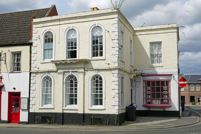
FORE STREET
1.
5411
(North West Side)
No 65
ST 8558 5/73 29.l2.50.
II GV
2.
Early C18. 2 storey and cellar. Brick on stone plinth. Chamfered bonded quoins.
Moulded stone string at 1st floor level, broken forward over quoins and keystones
to glazing bar sash windows. Stone frieze and moulded cornice with blocking course.
The front to Wicker Hill has 3 arched windows in stone architraves with keystones,
the centre ground floor window in Doric surround of pilasters and entablature,
possibly a former doorway. Cellar grilles under windows. The building has a return
to right hand of similar design with 2 windows on 1st floor, 1 on ground floor
and 6-panel door in right hand corner with stone surround of architrave and flat
moulded stone hood on cut stone scroll brackets, lining with 1st floor string.
A projecting wing to right facing south east has an early C19 bow window on ground
floor, brought here from elsewhere and a window above. Facing east is a mid C19
shop window with fluted pilasters and a blocked doorway with moulded architrave
to left.
Nos 65 to 68 (consec), Nos 70 to 73 (consec), railings and gates to Nos 68 and
70, dwarf stone wall to No 72, No 64 (Lloyds Bank) and Usher's Brewery Corner Block,
form an outstanding group with No 8 and premises occupied by K.J. Lestor to south
west of No 8 Wicker Hill.
Listing NGR: ST8552458068
External links are from the relevant listing authority and, where applicable, Wikidata. Wikidata IDs may be related buildings as well as this specific building. If you want to add or update a link, you will need to do so by editing the Wikidata entry.


Other nearby listed buildings
