Approximate Location Map
Large Map »
Latitude: 53.7186 / 53°43'6"N
Longitude: -1.8232 / 1°49'23"W
OS Eastings: 411765
OS Northings: 424700
OS Grid: SE117247
Mapcode National: GBR HTQF.2Q
Mapcode Global: WHC9M.YSZM
Plus Code: 9C5WP59G+CP
Entry Name: Sunny Bank Farmhouse
Listing Date: 2 December 1983
Last Amended: 2 February 1984
Grade: II
Source: Historic England
Source ID: 1184354
English Heritage Legacy ID: 338906
ID on this website: 101184354
Location: Hipperholme, Calderdale, West Yorkshire, HX3
County: Calderdale
Electoral Ward/Division: Town
Parish: Non Civil Parish
Traditional County: Yorkshire
Lieutenancy Area (Ceremonial County): West Yorkshire
Church of England Parish: Southowram St Anne-in-the-Grove
Church of England Diocese: Leeds
Tagged with: Farmhouse
This list entry was subject to a Minor Amendment on 8 September 2021 to remove superfluous amendment details and to reformat the text to current standards
SE 12 SW
3/168
BRIGHOUSE
SUNNYBANK LANE
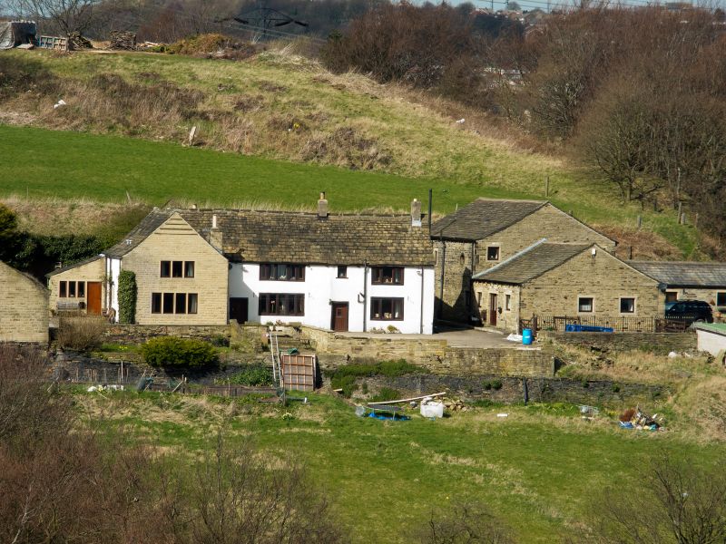
Sunny Bank Farmhouse
(Formerly listed as Sunnybank)
II
House. Late C15 timber-framed interior encased in stone probably mid C18. Hammer-dressed stone (rendered), stone slate roof. Hall and cross-wings plan, the left hand of which projects and has gable. Right hand under same roof as hall, except to rear where two gables flank single storey aisle under cat slide roof. South front has mid C18 details of three bays two storeys. First bay has three-light flat faced mullioned window with columbarium over. Hall range of two bays each having doorways with monolithic jambs and flat faced mullioned windows of six, four and three lights. Two stacks to ridge.
Interior: Much timber-framing survives, possibly from an earlier building. There is a timbered arcade between the aisle and hall with posts and braces visible. Board and muntin panelling to ground floor and close studded wall to first floor. Similarly the division wall between hall and west-wing was formerly divided by a timber partition of which the closed aisled truss remains which is a king-post truss with the unusual feature of cusped braces to the ridge. The west-wing was entered from the hall by two separate doorways the southern of which remains its ogee doorhead. There does not appear to have been an inter-connecting door between the two rooms in the wing.
The northern room retains its original fireplace in the west wall with a Tudor arched lintel and simple chamfered surround. A post and braces run in front of a stone wall and below the closing truss of the hall. Between the chambers is a closed king-post truss with eight vertical struts. The king post truss in the East-wing is closed with six vertical struts and is the only one with a diagonally set ridge. The projecting rear wing would appear to have been the service end with kitchen and possibly loom shop. Though externally this building has been altered, internally is preserved a C16 timber-frame largely untouched.
Listing NGR: SE1176524700
External links are from the relevant listing authority and, where applicable, Wikidata. Wikidata IDs may be related buildings as well as this specific building. If you want to add or update a link, you will need to do so by editing the Wikidata entry.


Other nearby listed buildings
