Approximate Location Map
Large Map »
Latitude: 51.8103 / 51°48'37"N
Longitude: -2.6531 / 2°39'11"W
OS Eastings: 355069
OS Northings: 212613
OS Grid: SO550126
Mapcode National: GBR FN.X4J4
Mapcode Global: VH86V.YRRK
Plus Code: 9C3VR86W+4Q
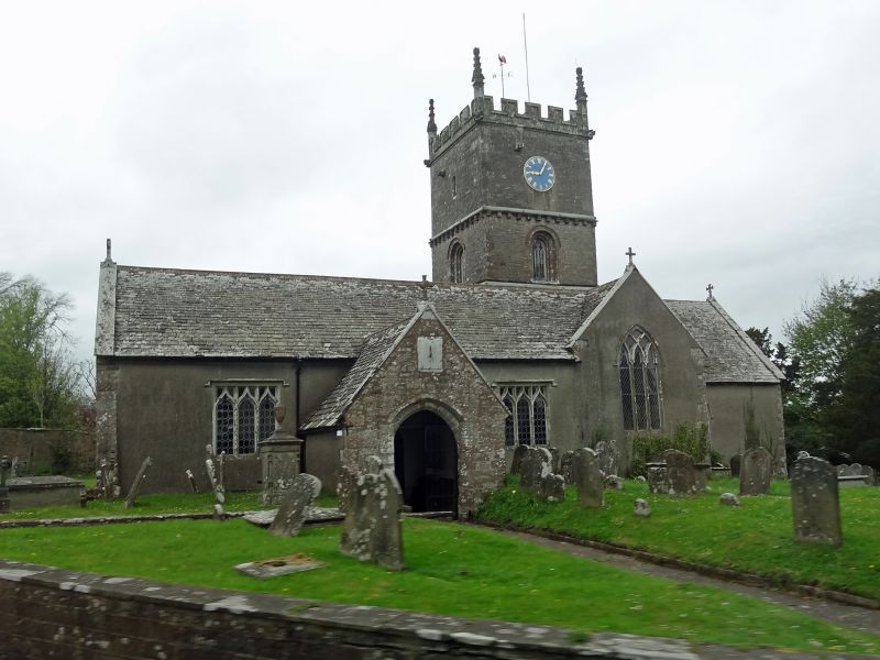
Entry Name: Church of All Saints
Listing Date: 12 December 1953
Grade: I
Source: Historic England
Source ID: 1186351
English Heritage Legacy ID: 353820
ID on this website: 101186351
Location: All Saint's Church, Staunton, Forest of Dean, Gloucestershire, GL16
County: Gloucestershire
District: Forest of Dean
Civil Parish: Staunton Coleford
Traditional County: Gloucestershire
Lieutenancy Area (Ceremonial County): Gloucestershire
Tagged with: Church building
SO 51 SE STAUNTON COLEFORD STAUNTON
4/131 Church of All Saints
12.12.53
I
Parish Church. Early C12, with alterations and additions through
the Medieval period, and some C19 restoration. Roughcast with
stone dressings, rubble stone porch, tower and west wall. Stone
slate roof with coped gables and cross finials. Crossing tower,
gabled south porch with sundial, single bay chancel, nave, north
and south aisles (north one truncated at west end). 2 stage tower
with corbel table between. Recessed round arches on south and
west faces on first stage, clock face on south face above.
Embattled parapet with corner pinnacles and gargoyles. Blind
arches on east chancel wall, below level of window, and 3 blind
arches in north west corner of nave, 2 to the west being round.
Mainly Perpendicular tracery with aisle windows of 3-light trefoils
with ogee heads.
Interior: Scissor beam nave roof, 5-bay arcade on south side with
moulded pointed Early English arches on cylindrical piers, some
with carved capitals. Base of tower C12, heightened in C15.
Stone pulpit on north west pier of tower with spiral stone rood
staircase inside leading to very narrow door in pier above.
Chancel added in C15, has several C17 floor tombstones. Victorian
pews, many with brass candlesticks. Fonts: Norman font under
south crossing arch, possibly originally a Roman altar, and C15
font in south west corner. Churchyard contains grave of David
Mushet, the metallurgist of Coleford, whose experiments
revolutionised the steel industry. (David Verey, Buildings of
England, Gloucestershire: The Vale and the Forest of Dean, 1980).
Listing NGR: SO5506812616
External links are from the relevant listing authority and, where applicable, Wikidata. Wikidata IDs may be related buildings as well as this specific building. If you want to add or update a link, you will need to do so by editing the Wikidata entry.


Other nearby listed buildings
