Latitude: 50.8316 / 50°49'53"N
Longitude: -0.1678 / 0°10'4"W
OS Eastings: 529122
OS Northings: 105158
OS Grid: TQ291051
Mapcode National: GBR JNX.SG7
Mapcode Global: FRA B6JW.Y5Z
Plus Code: 9C2XRRJJ+JV
Entry Name: 67, the Drive
Listing Date: 2 November 1992
Grade: II
Source: Historic England
Source ID: 1187588
English Heritage Legacy ID: 365629
ID on this website: 101187588
Location: Hove, Brighton and Hove, West Sussex, BN3
County: The City of Brighton and Hove
Electoral Ward/Division: Goldsmid
Parish: Non Civil Parish
Built-Up Area: Brighton and Hove
Traditional County: Sussex
Lieutenancy Area (Ceremonial County): East Sussex
Church of England Parish: Hove All Saints
Church of England Diocese: Chichester
Tagged with: Building
HOVE
TQ2905SW THE DRIVE 579-1/15/188 (West side) No.67
II
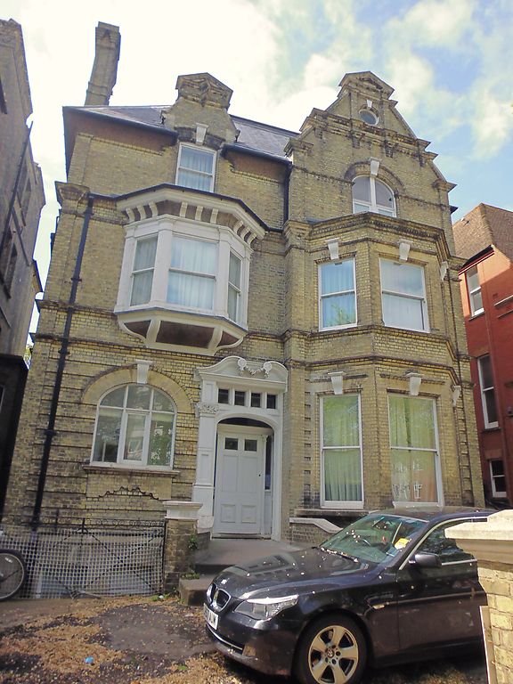
Villa. 1880's, built by William Willett. Yellow stock bricks with lavish use of moulded brick for Dutch gables. Hipped slate roof with Dutch gable to right and end stacks. 3 storeys with attic and basement. Gable to right, slightly projecting, has 2-storey bay with sash windows without glazing bars under flat-arched heads with prominent key blocks. Casement above under similar basket-arched head and decorative Dutch gable over with bull's eye window. Left has 1st floor slate-roofed canted oriel with C20 window above projecting into roof with small Dutch gable. Ground floor left has doorway with pilaster doorcase and swan's neck pediment, the right-hand part cut off by the projecting gable as an architectural feature. To left a window with cut-brick apron and basket-arched head.
Listing NGR: TQ2911705158
External links are from the relevant listing authority and, where applicable, Wikidata. Wikidata IDs may be related buildings as well as this specific building. If you want to add or update a link, you will need to do so by editing the Wikidata entry.


Other nearby listed buildings