Latitude: 51.3086 / 51°18'30"N
Longitude: -0.0821 / 0°4'55"W
OS Eastings: 533778
OS Northings: 158355
OS Grid: TQ337583
Mapcode National: GBR HW.7ZM
Mapcode Global: VHGRZ.JCGP
Plus Code: 9C3X8W59+C5
Entry Name: Coal Tax Post at Ngr TQ 337790 583560
Listing Date: 19 November 1984
Last Amended: 8 November 1999
Grade: II
Source: Historic England
Source ID: 1188255
English Heritage Legacy ID: 287700
ID on this website: 101188255
Location: Whyteleafe, Tandridge, Surrey, CR3
County: Surrey
District: Tandridge
Civil Parish: Whyteleafe
Built-Up Area: Croydon
Traditional County: Surrey
Lieutenancy Area (Ceremonial County): Surrey
Church of England Parish: Whyteleafe St Luke
Church of England Diocese: Southwark
Tagged with: Coal-tax post
TQ 35 NW CATERHAM & WARLINGHAM WHYTELEAFE HILL (West side), Whyteleafe 303/2/45 Coal Tax Post at NGR TQ 337790 583560 19.11.1984 II
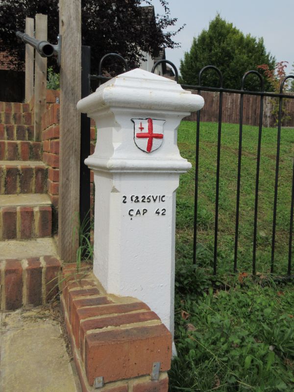
Coal tax post. c1861. Metal c41/2 foot high. Four legged plinth chamfered pier above with moulded capital band and pyramidal top. City of London Shield cast on the front, lettering below on the pier reading "24 & 25 VICT/CAP 42". A Coal and Wine tax post indicating the boundary at which duty was payable; that on coal dating back to the 1660's.
Listing NGR: TQ3377858355
External links are from the relevant listing authority and, where applicable, Wikidata. Wikidata IDs may be related buildings as well as this specific building. If you want to add or update a link, you will need to do so by editing the Wikidata entry.


Other nearby listed buildings