Latitude: 52.6772 / 52°40'37"N
Longitude: -2.1744 / 2°10'27"W
OS Eastings: 388303
OS Northings: 308845
OS Grid: SJ883088
Mapcode National: GBR 18D.330
Mapcode Global: WHBFC.KYSZ
Plus Code: 9C4VMRGG+V6
Entry Name: 7 and 9, Bargate Street
Listing Date: 16 May 1985
Grade: II
Source: Historic England
Source ID: 1188751
English Heritage Legacy ID: 271508
ID on this website: 101188751
Location: Brewood, South Staffordshire, ST19
County: Staffordshire
District: South Staffordshire
Civil Parish: Brewood and Coven
Built-Up Area: Brewood
Traditional County: Staffordshire
Lieutenancy Area (Ceremonial County): Staffordshire
Church of England Parish: Brewood St Mary and St Chad
Church of England Diocese: Lichfield
Tagged with: Building
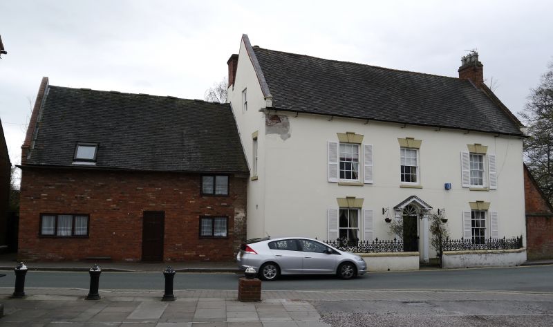
BREWOOD CP BARGATE STREET
SJ 80 NE
13/205 (South Side)
Nos 7 & 9
GV II
Shop premises, formerly house. C15, altered, especially in C18 and mid-C19. Painted brick, partially masking the surviving timber-frame, partly plastered; tiled roofs, 2-bay front with single bay rear wing to No. 9 and lean-to behind No 7. Now a low 2-storey house with brick-block cornice; small mid C19 casement to right on 1st floor; the front largely consists of 2 plain shop windows (the left-hand one, No 7 with glazing bars) and a central recessed entry (No. 9); No. 7 is entered from the chamfered left-hand corner. Raised brick verge to left-hand verge with stunted chimney; large chimney at right-hand gable and shared with No 11 (The White House)qv.
Interior: No 7 retains a massive crown post with down-swinging braces to a steeply cambered arch braced tie beam, presumably formerly in the upper chamber of the solar. No. 9 is part of a presumably formerly 2-bay open-hall with smoke-blackened rafters and a deep arch-braced collar central truss, both the brace and the wall-post have deeply moulded chamfers facing the upper end and simpler chamfers to the lower end. Portions of timber-framing survive between No. 9 of its rear wing on the 1st floor. The lower bay of the hall and the assumed service wing were demolished probably in the C18 when No 11 (The White House) qv was built with its gable and partly supported on the central hall truss. This apears to have been a timber-framed 4-bay open hall house. Crown posts with down-swinging braces are (up to now) comparatively rare in Staffordshire and Shropshire. This is a building whose plain exterior belies an important internal survival.
Listing NGR: SJ8830308844
External links are from the relevant listing authority and, where applicable, Wikidata. Wikidata IDs may be related buildings as well as this specific building. If you want to add or update a link, you will need to do so by editing the Wikidata entry.


Other nearby listed buildings