Approximate Location Map
Large Map »
Latitude: 51.4947 / 51°29'40"N
Longitude: -0.1565 / 0°9'23"W
OS Eastings: 528072
OS Northings: 178917
OS Grid: TQ280789
Mapcode National: GBR 9L.1C
Mapcode Global: VHGQZ.7PMJ
Plus Code: 9C3XFRVV+VC
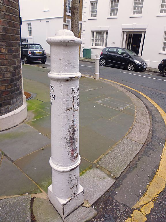
Entry Name: Bollard Outside Number 70
Listing Date: 7 November 1984
Grade: II
Source: Historic England
Source ID: 1189387
English Heritage Legacy ID: 203574
ID on this website: 101189387
Location: Belgravia, Kensington and Chelsea, London, SW1X
County: London
District: Kensington and Chelsea
Electoral Ward/Division: Royal Hospital
Parish: Non Civil Parish
Built-Up Area: Kensington and Chelsea
Traditional County: Middlesex
Lieutenancy Area (Ceremonial County): Greater London
Church of England Parish: Holy Trinity Sloane Square
Church of England Diocese: London
Tagged with: Bollard
TQ 2878 NW CADOGAN PLACE SW1
50/15
Bollard outside No 70
GV
II
Bollard outside No 70. Inscribed "Hans Town 1819". Iron cannon type.
(Included for group value with No 70).
Listing NGR: TQ2807278917
External links are from the relevant listing authority and, where applicable, Wikidata. Wikidata IDs may be related buildings as well as this specific building. If you want to add or update a link, you will need to do so by editing the Wikidata entry.


Other nearby listed buildings
