Approximate Location Map
Large Map »
Latitude: 51.5058 / 51°30'20"N
Longitude: -0.2076 / 0°12'27"W
OS Eastings: 524495
OS Northings: 180064
OS Grid: TQ244800
Mapcode National: GBR C8.SCY
Mapcode Global: VHGQY.CF30
Plus Code: 9C3XGQ4R+8X
Entry Name: 53, Holland Park W11
Listing Date: 15 April 1969
Grade: II
Source: Historic England
Source ID: 1191377
English Heritage Legacy ID: 203895
ID on this website: 101191377
Location: Notting Hill, Kensington and Chelsea, London, W11
County: London
District: Kensington and Chelsea
Electoral Ward/Division: Holland
Parish: Non Civil Parish
Built-Up Area: Kensington and Chelsea
Traditional County: Middlesex
Lieutenancy Area (Ceremonial County): Greater London
Church of England Parish: St George, Campden Hill
Church of England Diocese: London
Tagged with: Building
TQ 2480 SW HOLLAND PARK W11
23/46
15.4.69 No 53
GV
II
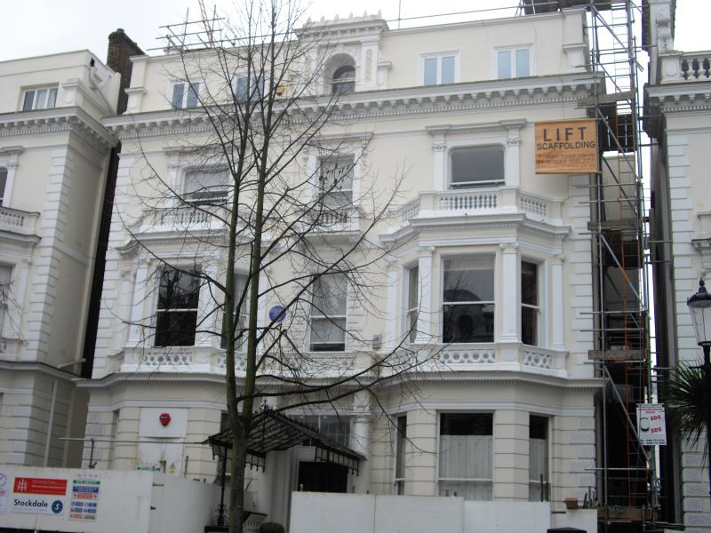
Detached house. 1862. Stucco. Three storeys, attic and basement. Three bays wide,
1:1:1, symmetrical. Channelling to ground floor. Steps to central entrance with Doric
half columns. Wrought and cast iron glazed canopy over steps. Two storey canted bay
window to each side with Ionic pilasters to upper storey. Pilasters to outer windows
on second floor. Small balustraded balcony to central window. Rich cornice. Attic
remodelled in stucco retaining central window. Cast iron balconies to ground floor.
Part of the Holland Park planned layout.
Listing NGR: TQ2449580064
External links are from the relevant listing authority and, where applicable, Wikidata. Wikidata IDs may be related buildings as well as this specific building. If you want to add or update a link, you will need to do so by editing the Wikidata entry.


Other nearby listed buildings
