Latitude: 53.5018 / 53°30'6"N
Longitude: -1.6303 / 1°37'48"W
OS Eastings: 424622
OS Northings: 400630
OS Grid: SE246006
Mapcode National: GBR KW1Y.VF
Mapcode Global: WHCBW.X7VS
Plus Code: 9C5WG929+PV
Entry Name: Take off Stone Approximately 250 Metres South of Junction with Mossley Road
Listing Date: 21 July 1986
Grade: II
Source: Historic England
Source ID: 1191616
English Heritage Legacy ID: 333865
ID on this website: 101191616
Location: Barnsley, South Yorkshire, S36
County: Barnsley
Civil Parish: Langsett
Traditional County: Yorkshire
Lieutenancy Area (Ceremonial County): South Yorkshire
Church of England Parish: Penistone St John the Baptist
Church of England Diocese: Sheffield
Tagged with: Architectural structure Take off stone
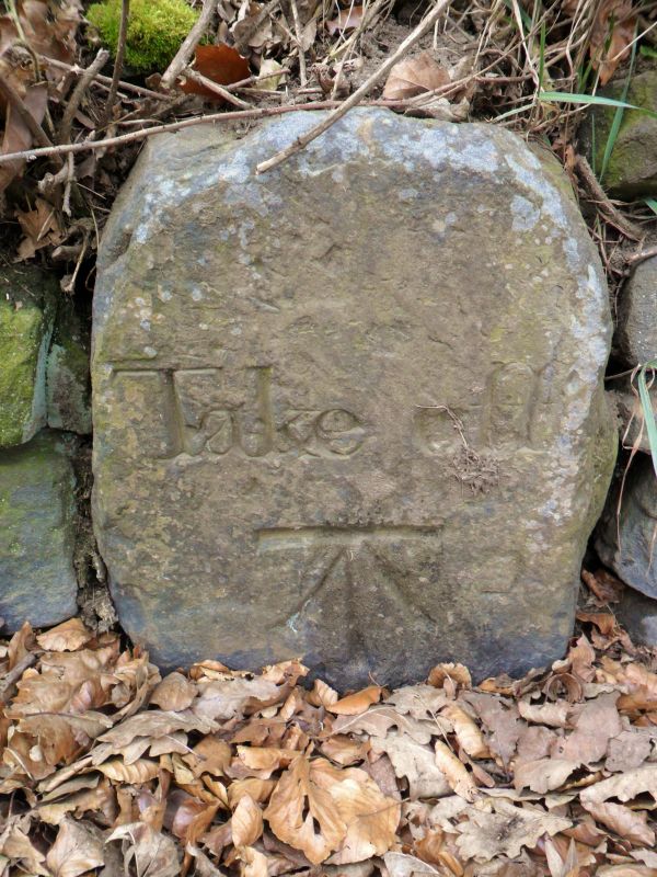
SE20SW LANGSETT MORTIMER ROAD SE2462 0063 (west side) Midhopestones 6/83 Take-off stone approx 250 metres south of junction with Mossley Road II Marker stone. Late C18. Stone post with rounded top with good incised letters reading 'Take Off'. Below this is an ordnance Survey bench mark. The stone is built into a dry-stone wall. The stone is at the top of the steep Mortimer Road, the Act for which was passed in 1770. The road, built by a Mr Mortimer, did not meet the required standard and thus tolls could not be enforced. Langsett township, which had to maintain the road, provided a horse to help wagons up the hill and at the top of the horse was 'taken-off' at the stone to return to the bottom. J Kenworthy, A History of Stocksbridge, 1927.
SE1OSE LANGSETT WOODHEAD ROAD SE1955 0153 (south side) Langsett 5/84 Milestone approx 200 metres west of Flouch Inn II Milestone. Probably early c19. Stone post with rounded top. Good incised letters read: Barnsley 11 Miles Manchester 25 Miles
Listing NGR: SE2462200630
External links are from the relevant listing authority and, where applicable, Wikidata. Wikidata IDs may be related buildings as well as this specific building. If you want to add or update a link, you will need to do so by editing the Wikidata entry.


Other nearby listed buildings