Approximate Location Map
Large Map »
Latitude: 51.5132 / 51°30'47"N
Longitude: -0.109 / 0°6'32"W
OS Eastings: 531316
OS Northings: 181056
OS Grid: TQ313810
Mapcode National: GBR MC.PR
Mapcode Global: VHGR0.277B
Plus Code: 9C3XGV7R+7C
Entry Name: 2 King's Bench Walk
Listing Date: 4 January 1950
Grade: I
Source: Historic England
Source ID: 1193156
English Heritage Legacy ID: 199534
ID on this website: 101193156
Location: Holborn, City of London, London, EC4Y
County: London
District: City and County of the City of London
Electoral Ward/Division: Farringdon Without
Parish: Non Civil Parish
Built-Up Area: City of London
Traditional County: Middlesex
Lieutenancy Area (Ceremonial County): City of London
Tagged with: Building
TQ 3181 SW
7/107
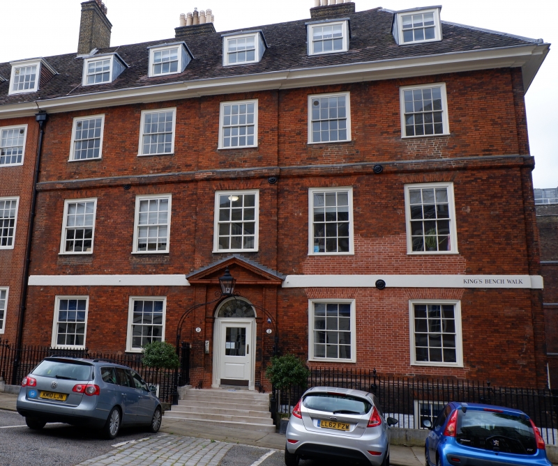
INNER TEMPLE EC4
King's Bench Walk (East Side)
No 2
4.1.50.
GV
I
Late C17. Three storeys plus basement and dormers. Five windows. Red brick with storey-bands (lower one painted). Eaves-cornice to tiled roof. Doorway similar to No 1. Three window south return. Area railings with lamp arch.
Listing NGR: TQ3131681056
External links are from the relevant listing authority and, where applicable, Wikidata. Wikidata IDs may be related buildings as well as this specific building. If you want to add or update a link, you will need to do so by editing the Wikidata entry.


Other nearby listed buildings
