Approximate Location Map
Large Map »
Latitude: 52.7569 / 52°45'24"N
Longitude: 0.3962 / 0°23'46"E
OS Eastings: 561802
OS Northings: 320394
OS Grid: TF618203
Mapcode National: GBR N3Q.4ZG
Mapcode Global: WHJP1.1YYV
Plus Code: 9F42Q94W+QF
Entry Name: 26 St Nicholas Street
Listing Date: 4 December 1970
Last Amended: 1 May 2018
Grade: II
Source: Historic England
Source ID: 1195395
English Heritage Legacy ID: 384301
ID on this website: 101195395
Location: North End, King's Lynn and West Norfolk, Norfolk, PE30
County: Norfolk
District: King's Lynn and West Norfolk
Electoral Ward/Division: St Margarets with St Nicholas
Parish: Non Civil Parish
Built-Up Area: King's Lynn
Traditional County: Norfolk
Lieutenancy Area (Ceremonial County): Norfolk
Tagged with: Building
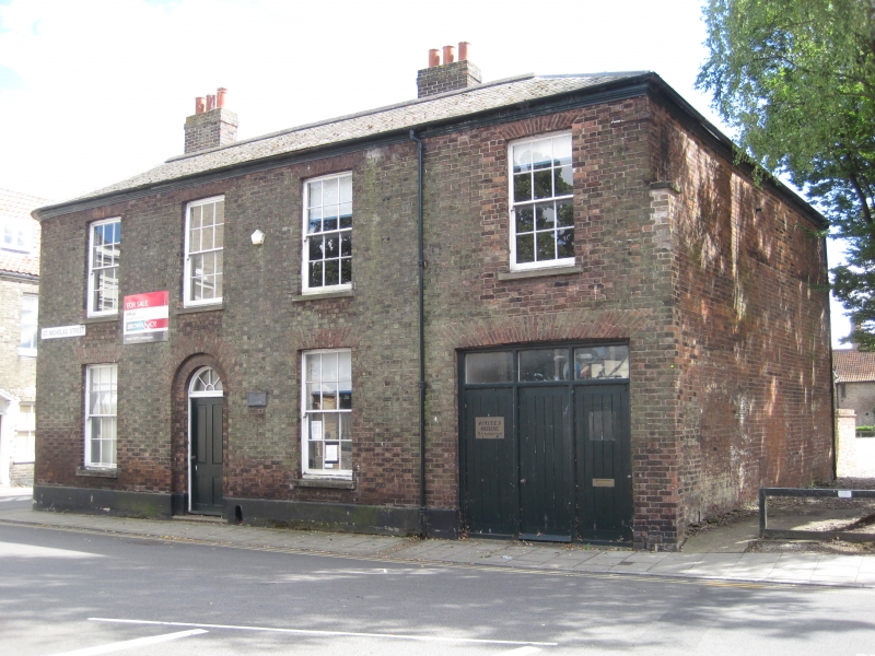
Brown-brick house, built 1841, renovated in 1987 and converted to offices.
House, built in 1841, renovated in 1987 and converted to offices.
MATERIALS: Brown brick walls and slate roof.
PLAN: Two-storey L-plan building, facing north to St Nicholas Street, curved at north-east corner.
EXTERIOR: Two-storey house, in brown brick, with a hipped slate roof. The rear slopes of the roof bear two brown-brick chimney stacks. The front (north) elevation to St Nicholas Street has three symmetrical bays, with an additional bay to the west comprising a sash window (replacing an earlier casement window) over a former carriage arch (now a door). The front elevation has a central timber-panelled door within recessed reveals, and a replacement spoked fanlight over. To the right of the door, a mid-C19 boot scrape survives, and the wall above bears a plaque commemorating the late C20 renovation which reads RESTORED BY / KING’S LYNN / PRESERVATION / TRUST 1987. The former carriage arch was infilled with a timber door, side panels and long overlight in 1987. The windows are all replacement horned timber sashes (1987), with the exception of a small number of casement windows to the rear elevation. The east elevation to Chapel Street has two blind bays, and a sash window to the centre of the first floor. The west elevation shows evidence of former door and window openings, infilled with red brick in 1987. The rear (south) elevation has a blocked, round-arched opening at its east end, and the rear projection at the west end appears to have been altered and extended at first floor height (as is evidenced by the use of stone) in the late C19 or early C20.
INTERIOR: The original plan form remains relatively intact, with the exception of the stair, which was turned around during renovation works in 1987. The front door opens to a central stair hall, off which there are two original timber-panelled doors to the east and west providing access to rooms overlooking St Nicholas Street. At ground and first-floor levels, the north-west room has a plain cornice, and a mid-C19 fireplace to the centre of the south wall, flanked by an elliptical-arched niche on either side. The north-east room contains a plain mid-C19 fireplace to the centre of the south wall at ground and first floor levels. At the end (south) of the stair hall, the corridor turns west, and a glazed-partitioned wall provides borrowed light from an office to the rear corridor. The former carriage arch at the west end of the building has stone slabs to its entrance porch, and two glazed partitions (introduced 1987) dividing the former carriage passage into office spaces.
SUBSIDIARY FEATURES: A red brick boundary wall and railings, constructed in the late C20, enclose a small yard at the rear of the building.
King’s Lynn, first called Bishop’s Lynn, was founded in 1095 by Bishop Herbert de Losinga, who in the previous year had transferred the see from Thetford to Norwich. There was already an existing settlement which appears to have been based around a salt-water lagoon, or series of inlets, with its centre round the present All Saints Church. Losinga’s town developed to the north of this, between All Saints Church and Saturday Market Place where St Margaret’s Church and Priory were established from Norwich around 1100. Rapid expansion from the C12 onwards required an extension of the town, and Bishop William Turbe laid out a new settlement north of the Purfleet from around 1145, with its market at Tuesday Market Place and the Chapel of St Nicholas as a chapel of ease to St Margaret’s. Both settlements were united under a royal charter in 1204, the united town being named Bishop’s Lynn. Until the early C13, the Great Ouse emptied via the Wellstream at Wisbech, however following floods in the C13, the river was redirected to join the Wash at Bishop’s Lynn. The town became one of England’s busiest ports, serving the Ouse and its tributaries, exporting wool and cloth, and importing wine, timber and luxury goods, being adopted as a member of the original medieval Hanseatic League. This extremely influential trading association linked a group of towns around the Baltic and the North Seas, and played an important role in the prosperity and development of Bishop’s Lynn as a national port, which by the C14, was ranked as the third port of England (after London and Southampton).
Losinga’s town round the Saturday Market was protected from the river immediately to its west by the ‘great bank’, an earthwork which ran along the present line of Nelson Street, St Margaret’s Place and Queen Street. By about 1500 the river had moved approximately 50m west and was consolidated another 45m by the new South Quay in 1855. The period of development of the area between the Millfleet and Purfleet can therefore be identified, as well as building types and plans. The generous-sized plots are reflected in the surviving buildings dating from the C14 to the C17, which surround open courtyards. To the north, on Bishop Turbe’s ‘newe lande’, much the same pattern emerges: originally the west side of Tuesday Market Place was washed by the river, with King Street forming the line of the bank. The west side of King Street was built upon in the C13, with narrow plots, elongating in stages until river movement ceased in the C17. As land became available, warehouses were built straight onto the river front. When Henry VIII dissolved the monasteries in 1536-1537, the town and manor became royal property, and Bishop’s Lynn was renamed King’s Lynn or Lynn Regis.
Lynn’s prosperity as a national port was based entirely on trade, and the merchant class dominated the social and economic life of the town until the C19. When the Fens began to be drained in the mid-C17 and land turned to agricultural use, King’s Lynn grew prosperous from the export of corn: cereal export dominated from the C16, and especially in the C18. Coal and wine continued to be imported for distribution inland, and until the railway age, Lynn was the chief East Anglian port for both. Prosperity continued until continental trade was disturbed by the Napoleonic Wars (1803-1815), followed by a brief revival. The economy and population dwindled following the relatively late arrival of railway services to King’s Lynn in 1847, compounded by the irrevocable decline of coastal trading.
Located directly opposite the gates of the Chapel of St Nicholas, 26 St Nicholas Street was constructed in 1841 to replace an earlier structure, and its distinctive rounded north-eastern corner demonstrates the rebuilding and improvements undertaken by the paving commissioners in King's Lynn at the start of the C19. Late C19 Ordnance Survey (OS) mapping shows the L-plan building as having a small structure attached to its west elevation facing St Nicholas Street, and a terrace of buildings attached to the rear (south) elevation facing Chapel Street. Comparison of historic OS mapping indicates that a long hall was built around 1910 attached to the west side of the building, and a mid-C20 photograph shows the hall with a gabled front to St Nicholas Street before it was demolished around 1970.
In 1970 the former King’s Lynn Borough Council proposed the realignment of Austin Street and St Nicholas Street for the re-development of the area, involving the demolition of properties along the south side of St Nicholas Street and west side of Chapel Street. Following a public enquiry, 26 St Nicholas Street was excluded from the compulsory purchase order and so it stands in isolation at the junction of Chapel Street and St Nicholas Street. The area to the rear (south) of the building was gradually cleared towards Ravenshaw’s Yard in the late C20, and a council car park was established on the cleared ground.
In 1977, 26 St Nicholas Street was included in a ‘Heritage in Danger’ report produced by the King’s Lynn Preservation Trust (KLPT). By 1986 it was in a poor condition and unoccupied, and was acquired by the KLPT the same year following compulsory purchase proceedings. Restoration work commenced in 1987 with grant assistance from English Heritage (now Historic England): the staircase was turned around to improve circulation; the workshop area was modified by adding new windows to the south elevation; and the first floor reinstated. On completion, the building was purchased from the Trust by a private individual.
26 St Nicholas Street, built as a house in 1841 and converted to offices in 1987, is listed at Grade II for the following principal reasons:
Architectural interest:
* distinctively detailed C19 town house, later converted to commercial use as offices.
Group value:
* for the strong group value it holds with many nearby listed buildings on St Nicholas Street and Chapel Street, notably the Chapel of St Nicholas (listed at Grade I), the Tudor Rose Hotel (listed at Grade II*), and 78 and 80 Chapel Street (both listed at Grade II).
External links are from the relevant listing authority and, where applicable, Wikidata. Wikidata IDs may be related buildings as well as this specific building. If you want to add or update a link, you will need to do so by editing the Wikidata entry.


Other nearby listed buildings
