Latitude: 52.4165 / 52°24'59"N
Longitude: 0.7485 / 0°44'54"E
OS Eastings: 587016
OS Northings: 283391
OS Grid: TL870833
Mapcode National: GBR RD7.J2P
Mapcode Global: VHKCC.XJLB
Plus Code: 9F42CP8X+JC
Entry Name: Almshouses Including Surrounding Wall and Outbuildings
Listing Date: 1 December 1993
Grade: II
Source: Historic England
Source ID: 1195927
English Heritage Legacy ID: 384717
ID on this website: 101195927
Location: Thetford, Breckland, Norfolk, IP24
County: Norfolk
District: Breckland
Civil Parish: Thetford
Built-Up Area: Thetford
Traditional County: Norfolk
Lieutenancy Area (Ceremonial County): Norfolk
Church of England Parish: Thetford St Cuthbert
Church of England Diocese: Norwich
Tagged with: Almshouse
THETFORD
TL8783 CROXTON ROAD 617-1/6/51 (East side) Nos.2-8 (Even) Almshouses including surrounding wall and outbuildings
II
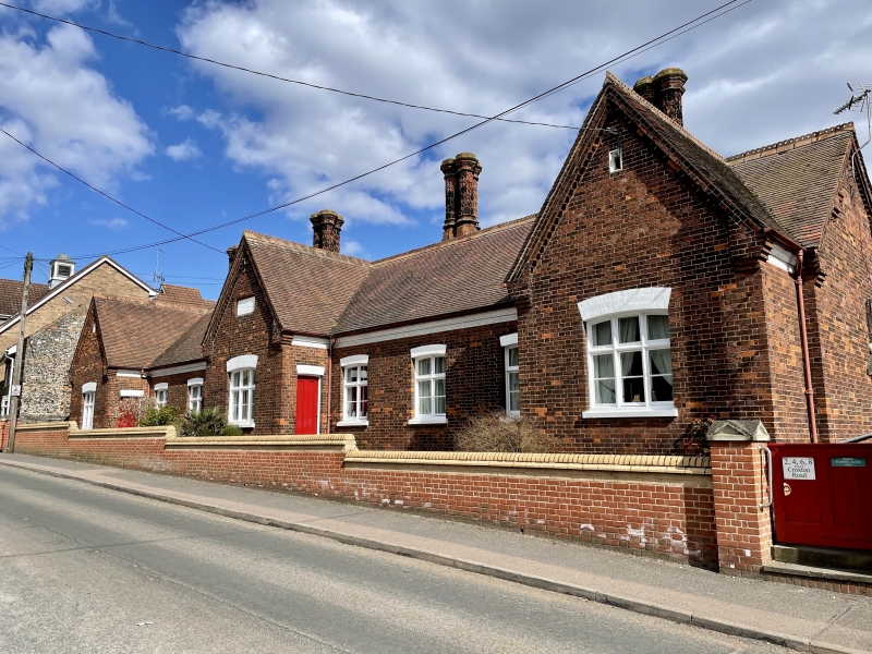
4 almshouses. 1885. Erected for George and Sarah Tyrrell. Red brick. Machine tile roof. One storey. Central projecting bay under a gable and one similar bay at right and left of elevation, 3 in all. Between gables are three 2-light cross casements under segmental heads and in gable ends are one 3-light cross casement each. Doors are 2-panelled. Gabled roof above moulded brick eaves cornice with an inverted arched frieze. 4 moulded stacks with triple flues. Rear with continuous row of 2-light and single-light casements and doorways under segmental heads. Boundary wall encloses building on all sides and at rear is developed into gabled outbuildings. INTERIOR not inspected.
Listing NGR: TL8701483380
External links are from the relevant listing authority and, where applicable, Wikidata. Wikidata IDs may be related buildings as well as this specific building. If you want to add or update a link, you will need to do so by editing the Wikidata entry.


Other nearby listed buildings