Approximate Location Map
Large Map »
Latitude: 52.1887 / 52°11'19"N
Longitude: 0.9964 / 0°59'47"E
OS Eastings: 604920
OS Northings: 258723
OS Grid: TM049587
Mapcode National: GBR SJM.LS0
Mapcode Global: VHKDP.7840
Plus Code: 9F425XQW+FH
Entry Name: 11 and 13, Station Road
Listing Date: 19 April 1972
Grade: II
Source: Historic England
Source ID: 1195940
English Heritage Legacy ID: 384637
ID on this website: 101195940
Location: Stowmarket, Mid Suffolk, IP14
County: Suffolk
District: Mid Suffolk
Civil Parish: Stowmarket
Built-Up Area: Stowmarket
Traditional County: Suffolk
Lieutenancy Area (Ceremonial County): Suffolk
Church of England Parish: Stowmarket St Peter and St Mary
Church of England Diocese: St.Edmundsbury and Ipswich
Tagged with: Building
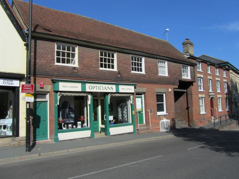
STOWMARKET
TM0458 STATION ROAD
614-1/4/109 (North side)
19/04/72 Nos.11 AND 13
GV II
Formerly known as: White Horse Inn.
2 shops. C15 or C16, altered C20. Formerly the White Horse
Inn, converted to shop 1903. Timber-framed. Front given brick
skin to ground floor and tile hanging to first floor C20. 2
storeys; 5-window front. Ground floor with square-headed
carriage arch to right. C20 double shopfront left of centre
replacing public house facade 1903. One C20 door and doorway
left, one C20 glazed door in C19 position right. Right again
is a C20 sash without glazing bars. Carriage arch retains 2
cranked braces with stylised foliage carving and moulded
jambs. First floor with five 4/8 late C19 horned sashes.
Gabled roof. Within carriage passage some timber-framing
visible. Rear with a roughcast timber-framed extension to west
(right) and a gault brick hipped and slated extension to east
(left). 3 red brick stacks on line of original outside wall.
(Double H: Stowmarket - A Book of Records: Stowmarket: 1983-:
P.107).
Listing NGR: TM0492058723
External links are from the relevant listing authority and, where applicable, Wikidata. Wikidata IDs may be related buildings as well as this specific building. If you want to add or update a link, you will need to do so by editing the Wikidata entry.


Other nearby listed buildings
