Approximate Location Map
Large Map »
Latitude: 53.7363 / 53°44'10"N
Longitude: -2.9594 / 2°57'33"W
OS Eastings: 336813
OS Northings: 427082
OS Grid: SD368270
Mapcode National: GBR 7TS7.3C
Mapcode Global: WH85P.JC01
Plus Code: 9C5VP2PR+G7
Entry Name: 11, East Beach
Listing Date: 13 January 1971
Last Amended: 15 February 1993
Grade: II
Source: Historic England
Source ID: 1196399
English Heritage Legacy ID: 385242
ID on this website: 101196399
Location: Lytham, Fylde, Lancashire, FY8
County: Lancashire
District: Fylde
Electoral Ward/Division: Clifton
Parish: Non Civil Parish
Built-Up Area: Lytham St Anne's
Traditional County: Lancashire
Lieutenancy Area (Ceremonial County): Lancashire
Church of England Parish: Lytham St John the Divine
Church of England Diocese: Blackburn
Tagged with: Architectural structure
This list entry was subject to a Minor Amendment on 07/02/2020
SD3627SE
621-1/6/26
LYTHAM ST ANNES
Lytham
EAST BEACH (north side)
No.11
(Formerly listed as No. 11 The Coppice CENTRAL BEACH (north side), previously listed as: EAST BEACH (north side), Lytham, Nos.10-11 The Coppice)
13/01/71
GV
II
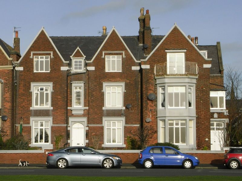
Formerly listed by inclusion with No.10. Marine villa, now flats. Dated 1847 on parapet of porch. Red brick in Flemish bond, with sandstone dressings and slate roof.
Irregular single-fronted plan, the rear interlocked with No.10 to the left. Two and a half storeys, presenting a gabled one-window facade which has a large stone two storey canted bay window with wooden casements and a C20 balcony on top (serving an altered attic window in the gable); and gable coping with kneelers. Ridge chimney coupled with that of No.10 to the left. The right-hand return wall steps out, and has a flat-roofed porch in the angle, with a Tudor-style doorway and a parapet with a worn lettered datestone dated 1847; and a gabled wing with C20 canted oriels on three levels.
Forms group with No.10 to the left (q.v.) and with Nos 12 and 12A to the right (q.v.), and is part of a noteworthy seaside development of villas and boarding houses.
Listing NGR: SD3660427064
External links are from the relevant listing authority and, where applicable, Wikidata. Wikidata IDs may be related buildings as well as this specific building. If you want to add or update a link, you will need to do so by editing the Wikidata entry.


Other nearby listed buildings
