Latitude: 52.2045 / 52°12'16"N
Longitude: -3.0268 / 3°1'36"W
OS Eastings: 329924
OS Northings: 256754
OS Grid: SO299567
Mapcode National: GBR F5.37TK
Mapcode Global: VH778.HV6C
Plus Code: 9C4R6X3F+R7
Entry Name: Numbers 32 and 32A Including Outbuildings to Left
Listing Date: 26 July 1976
Last Amended: 31 December 1993
Grade: II
Source: Historic England
Source ID: 1196534
English Heritage Legacy ID: 385841
ID on this website: 101196534
Location: Kington, County of Herefordshire, HR5
County: County of Herefordshire
Civil Parish: Kington
Built-Up Area: Kington
Traditional County: Herefordshire
Lieutenancy Area (Ceremonial County): Herefordshire
Church of England Parish: Kington
Church of England Diocese: Hereford
Tagged with: Building
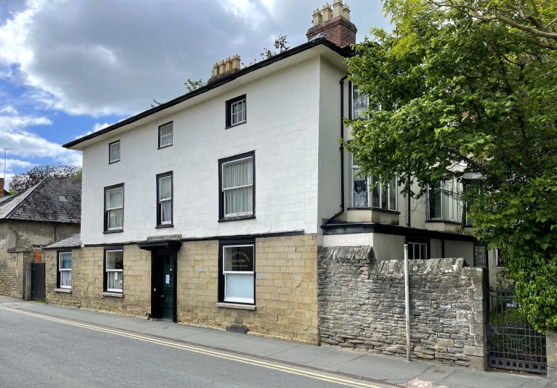
KINGTON
SO2956 DUKE STREET
643-1/1/77 (North West side)
26/07/76 Nos.32 AND 32A
including outbuildings to left
(Formerly Listed as:
DUKE STREET
(North West side)
Premises occupied by Vaughan &
Davies (including barn to left))
GV II
Houses, now offices. Early C19. Ashlar (to ground floor);
stucco; hipped Welsh slate roof; 2 brick axial stacks; brick
stacks to rear. 3 storeys and cellar; 3-window range: C20
plain sashes, in moulded cases; central casement, flanked by
fixed lights, in moulded cases. Central entrance: part-glazed
6-panel door in moulded architrave, under C20 restored wood
flat hood, on fluted pilasters; flanked by plain sashes, in
moulded cases. Right returned side: two 2-tier canted bays,
and canted oriel, with coloured leaded lights, over outshut
with two 6/6 sashes in moulded cases. Later outshut to left,
with plain sash in moulded case; similar sash to left returned
side; yellow brick stack. Rear wing: stucco with hipped
"turnerized" slate roof and rubble stack to rear; 3-light
casement in moulded case over deep jetty. Wing to left with
gable to road; roughcast over coursed rubble; hipped
"turnerized" Welsh slate roof; loft door; 3-light casement
with leaded lights, and various windows and doors, to right
returned side.
Listing NGR: SO2992456754
External links are from the relevant listing authority and, where applicable, Wikidata. Wikidata IDs may be related buildings as well as this specific building. If you want to add or update a link, you will need to do so by editing the Wikidata entry.


Other nearby listed buildings