Approximate Location Map
Large Map »
Latitude: 51.6007 / 51°36'2"N
Longitude: -1.8657 / 1°51'56"W
OS Eastings: 409398
OS Northings: 189103
OS Grid: SU093891
Mapcode National: GBR 3SF.P3C
Mapcode Global: VHB3C.M117
Plus Code: 9C3WJ42M+7P
Entry Name: Milestone 140 Metres North of Pound Farm
Listing Date: 17 April 1986
Grade: II
Source: Historic England
Source ID: 1198327
English Heritage Legacy ID: 317957
ID on this website: 101198327
Location: Widham, Wiltshire, SN5
County: Wiltshire
Civil Parish: Purton
Traditional County: Wiltshire
Lieutenancy Area (Ceremonial County): Wiltshire
Church of England Parish: Purton
Church of England Diocese: Bristol
Tagged with: Milestone
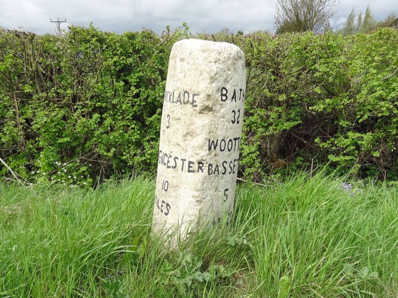
SU 08 NE PURTON CRICKLADE ROAD
(west side)
8/310 Milestone 140m north of
Pound Farm
II
Milestone. Early C19. Limestone. Triangular stem with convex
sides on square base. Lettering incised and now illegible.
Overpainted with legends: Left: CRICKLADE 5 Miles, CIRENCESTER 10
Miles. Right: WOOTTON BASSETT 3 Miles. On top: BATH 32 Miles.
Listing NGR: SU0939889103
External links are from the relevant listing authority and, where applicable, Wikidata. Wikidata IDs may be related buildings as well as this specific building. If you want to add or update a link, you will need to do so by editing the Wikidata entry.


Other nearby listed buildings
