Approximate Location Map
Large Map »
Latitude: 51.5617 / 51°33'42"N
Longitude: -1.7911 / 1°47'27"W
OS Eastings: 414580
OS Northings: 184781
OS Grid: SU145847
Mapcode National: GBR YPT.RG
Mapcode Global: VHB3L.X00L
Plus Code: 9C3WH665+MH
Entry Name: The Mechanics' Institute
Listing Date: 17 February 1970
Grade: II*
Source: Historic England
Source ID: 1198947
English Heritage Legacy ID: 318752
Also known as: The Mechanics Institute
ID on this website: 101198947
Location: Swindon, Wiltshire, SN1
County: Swindon
Electoral Ward/Division: Central
Parish: Central Swindon South
Built-Up Area: Swindon
Traditional County: Wiltshire
Lieutenancy Area (Ceremonial County): Wiltshire
Church of England Parish: Swindon New Town
Church of England Diocese: Bristol
Tagged with: Theatre
SU 1484 NE
1097/6/90
SWINDON,
EMLYN SQUARE,
The Mechanics' Institute
17.02.70
GV
II*
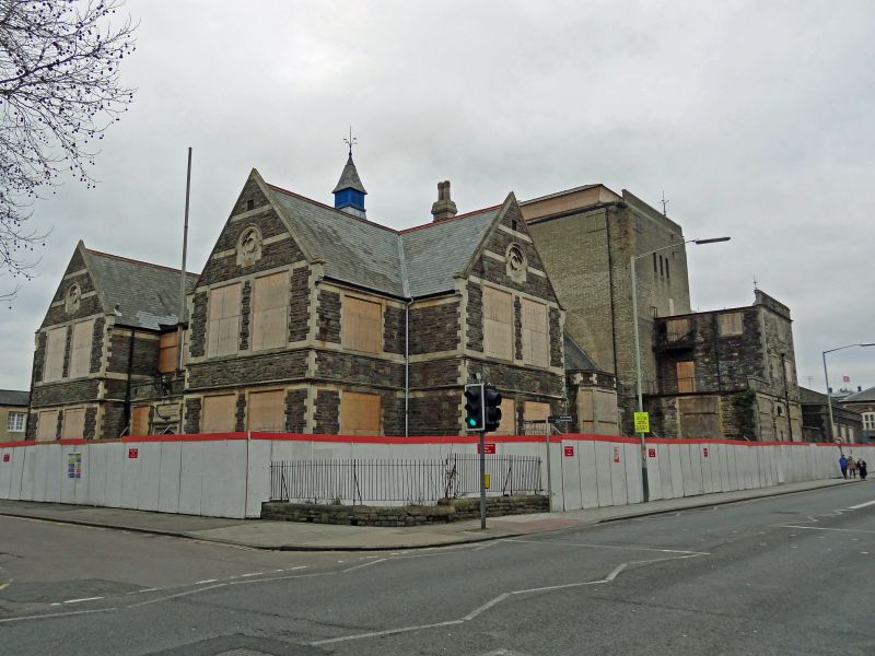
Former Mechanics' Institute, at present vacant. 1853-1855 by Edward Roberts of London. Considerably enlarged 1892-1893 by Brightwen Binyon.
Limestone rubble with ashlar quoins and dressings. Two-storey with raised central hall/theatre. Gothic Revival style. Ground floor: library and reading room, coffee room, mess room and baths, with entrance to north, facing works, and rear octagonal market hall opened 1855, now replaced. Ground floor triple entrances, painted segmental heads between buttresses, all in two-storey forebuilding. Cross windows above. Links to octagonal crenellated corner towers with slated spires and louvred lantern, the towers returning to square at ground level, and having Tudor-arched lights. Clocks in parapets. Behind forebuilding large Perpendicular style window to hall gable. Side buttresses and triple lights. Flat roofed attached single storey side buildings later in date, with Tudor glazing and entrance. Hipped slated corner canopies on bracketed cast-iron columns. Octagonal flanking lantern towers at south end of hall.
Major enlargement to south, 1892, in Jacobethan style. Coursed rock-faced rubble and slate roofs. Two-storey, two-bay end gables with Tudor three-light windows and carved quatrefoil in gables. Three-bay recessed centre with central Tudor door and recessed glazed gallery at first floor level. Four-light dormers and louvred lantern. Side elevations with projecting gable and hall with chamfered two-storey Tudor style windows; four dormers each side. Central theatre fly tower of 1930, built following a fire.
INTERIOR. In later section, in addition to various large rooms, an imposing five-bay reading room, with segmental vaulted ceiling and part-panelled walls. Theatre dressing rooms over. In earlier part, the first-floor assembly hall/theatre 76ft x 40ft with moulded plaster decorative frieze and vaulted ceiling. Stage with proscenium arch a semi-circular replacement of 1930, with moulded archivolt in art-deco style. Curving balcony with decorative front. (Original plan in The Builder, 1st July 1854).
HISTORY. This institute, which is the major architectural feature at the heart of Swindon Railway Village, is of considerable historic significance both for the mode of formation and for the range, importance and influence of the various facilities provided. The GWR set up a separate company, the New Swindon Improvement Co., as a workers' welfare venture, to build an institute, shops and market stalls all in one, fresh produce not being easily available. The original market stalls were demolished in 1891 to make room for the large addition which is itself a visible expression of the impressive breadth of the institute's work for over a 100 years. An extensive range of classes and lectures were provided for both men and women, and technical education was particularly important, this being harmonised with the progress of apprentices and students through the railway works itself. This institute also appears to be a unique survivor of one associated with a railway company.
BIBLIOGRAPHY :
Transport History (K Hudson); Swindon Retrospect 1855-1930 (F Large), 1931; The Great Western at Swindon Works (A Peck), 1983; A Swindon History 1840-1901 ( J Silto); The Builder, 1 July, 1854; Swindon: the Legacy of a Railway Town O Cattell and K Falconer), 1995; New Swindon Mechanics' Institution Preservation Trust, Lecture by T Cockbill, 1997.
Listing NGR: SU1458084781
External links are from the relevant listing authority and, where applicable, Wikidata. Wikidata IDs may be related buildings as well as this specific building. If you want to add or update a link, you will need to do so by editing the Wikidata entry.


Other nearby listed buildings
