Latitude: 51.7464 / 51°44'47"N
Longitude: -1.399 / 1°23'56"W
OS Eastings: 441588
OS Northings: 205471
OS Grid: SP415054
Mapcode National: GBR 7XM.F3Q
Mapcode Global: VHC09.PCRK
Plus Code: 9C3WPJW2+H9
Entry Name: 5-7, Steady's Lane
Listing Date: 17 October 1988
Grade: II
Source: Historic England
Source ID: 1199790
English Heritage Legacy ID: 252415
ID on this website: 101199790
Location: Stanton Harcourt, West Oxfordshire, OX29
County: Oxfordshire
District: West Oxfordshire
Civil Parish: Stanton Harcourt
Built-Up Area: Stanton Harcourt
Traditional County: Oxfordshire
Lieutenancy Area (Ceremonial County): Oxfordshire
Church of England Parish: Stanton Harcourt
Church of England Diocese: Oxford
Tagged with: Building Thatched cottage
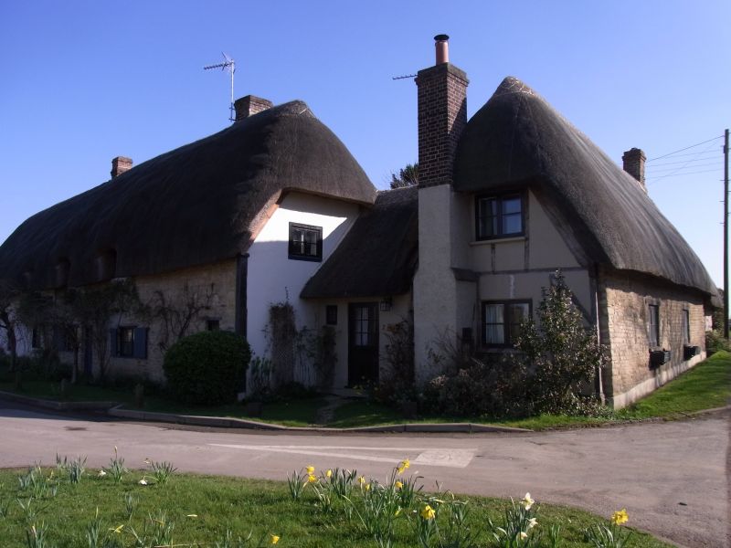
STANTON HARCOURT STEADY'S LANE
SP4105 (South side)
21/331 Nos.5/6 and 7
GV II
Two houses. Nos.5/6: C17, with late C17/early C18 extension. Coursed limestone
rubble; render over C17 timber frame on limestone rubble plinth to left;
half-hipped thatch roof; brick ridge stacks. 2- extended to 4-unit plan. One
storey and attic; 5-window range. No.5/6 has (to left) C20 casements and blocked
door, then chamfered timber lintel over central C20 plank door, and
stop-chamfered timber lintels over C19 three-light casements with shutters;
dormers have 3-light leaded and C19 three-light casements. Interior not
inspected but likely to be of interest. No.7 to rear right: late C17. Light
timber framing to front and right gable, rest of coursed limestone rubble;
half-hipped thatch roof; C20 brick end stack. Central C20 door and C19 two- and
-3-light casements set in earlier wood-mullioned windows. Interior: plain beam,
winder stairs with old Plank door and open fireplace with chamfered bressumer.
Listing NGR: SP4158805471
External links are from the relevant listing authority and, where applicable, Wikidata. Wikidata IDs may be related buildings as well as this specific building. If you want to add or update a link, you will need to do so by editing the Wikidata entry.


Other nearby listed buildings