Latitude: 51.8983 / 51°53'53"N
Longitude: -1.1516 / 1°9'5"W
OS Eastings: 458473
OS Northings: 222537
OS Grid: SP584225
Mapcode National: GBR 8XB.X8P
Mapcode Global: VHCX4.0K13
Plus Code: 9C3WVRXX+89
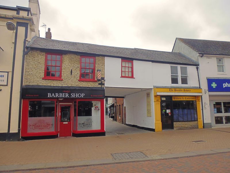
Entry Name: 29 and 31, Sheep Street
Listing Date: 20 March 1970
Grade: II
Source: Historic England
Source ID: 1200565
English Heritage Legacy ID: 243587
ID on this website: 101200565
Location: Bicester, Cherwell, Oxfordshire, OX26
County: Oxfordshire
District: Cherwell
Civil Parish: Bicester
Built-Up Area: Bicester
Traditional County: Oxfordshire
Lieutenancy Area (Ceremonial County): Oxfordshire
Church of England Parish: Bicester with Caversfield
Church of England Diocese: Oxford
Tagged with: Building
BICESTER SHEEP STREET SP5822N (West side) 2/l12 Nos.29 and 31 20/03/70 GV II
Shops and dwellings. Late C18 and C19. Part-rendered coursed limestone rubble; brick; Welsh-slate roof. Single range with central vehicular entry plus rear extensions. 2 storeys. No.29, to left, has a late-C19 shop front with arched window heads and a recessed central door, and has two 12-pane sashes at first floor set in rubble walling; a rendered bay over the central entry has a 9-pane sash. No.31 has C19 double sash over a C20 shop front. No.29 has a small rubble rear range with its ridge parallel to the main range; C19 rear wing of No.31 of brick in Flemish bond. Interiors not inspected.
Listing NGR: SP5847422531
External links are from the relevant listing authority and, where applicable, Wikidata. Wikidata IDs may be related buildings as well as this specific building. If you want to add or update a link, you will need to do so by editing the Wikidata entry.


Other nearby listed buildings