Approximate Location Map
Large Map »
Latitude: 50.3523 / 50°21'8"N
Longitude: -4.4593 / 4°27'33"W
OS Eastings: 225142
OS Northings: 53158
OS Grid: SX251531
Mapcode National: GBR NG.W0F3
Mapcode Global: FRA 18K3.DLB
Plus Code: 9C2Q9G2R+W7
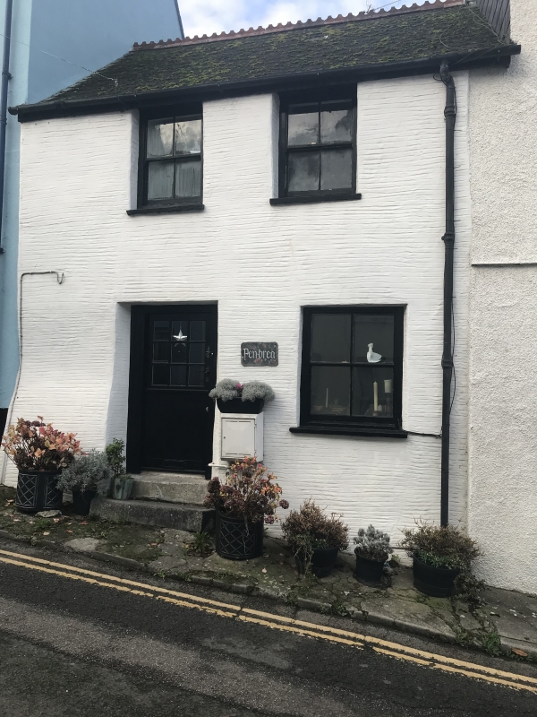
Entry Name: Pen Brea
Listing Date: 17 September 1973
Grade: II
Source: Historic England
Source ID: 1201126
English Heritage Legacy ID: 376456
ID on this website: 101201126
Location: West Looe, Cornwall, PL13
County: Cornwall
Civil Parish: Looe
Built-Up Area: Looe
Traditional County: Cornwall
Lieutenancy Area (Ceremonial County): Cornwall
Church of England Parish: St Martin with St Nicholas, Looe
Church of England Diocese: Truro
Tagged with: Architectural structure
LOOE
SX2453 WEST LOOE HILL, West Looe
857-1/4/107 (North side)
17/09/73 Pen Brea
GV II
Small house in row. C18. Rough-rendered rubble; steep asbestos
slate roof with late C19 crested clay ridge tiles.
Shallow-depth plan plus rear extension. 2 storeys; 2-window
range. Mid/late C19 4-pane hornless sashes or possibly early
C19 sashes with some glazing bars removed. Doorway under
left-hand window with C20 part-glazed door. INTERIOR not
inspected. Included for group value.
Listing NGR:SX2514253158
External links are from the relevant listing authority and, where applicable, Wikidata. Wikidata IDs may be related buildings as well as this specific building. If you want to add or update a link, you will need to do so by editing the Wikidata entry.


Other nearby listed buildings
