Approximate Location Map
Large Map »
Latitude: 51.9918 / 51°59'30"N
Longitude: -2.159 / 2°9'32"W
OS Eastings: 389180
OS Northings: 232606
OS Grid: SO891326
Mapcode National: GBR 1JR.10H
Mapcode Global: VH93T.J6HF
Plus Code: 9C3VXRRR+PC
Entry Name: 89 and 90, Church Street
Listing Date: 4 March 1952
Grade: II*
Source: Historic England
Source ID: 1201225
English Heritage Legacy ID: 376723
ID on this website: 101201225
Location: Tewkesbury, Gloucestershire, GL20
County: Gloucestershire
District: Tewkesbury
Civil Parish: Tewkesbury
Built-Up Area: Tewkesbury
Traditional County: Gloucestershire
Lieutenancy Area (Ceremonial County): Gloucestershire
Church of England Parish: Tewkesbury St Mary the Virgin (Tewkesbury Abbey)
Church of England Diocese: Gloucester
Tagged with: Building
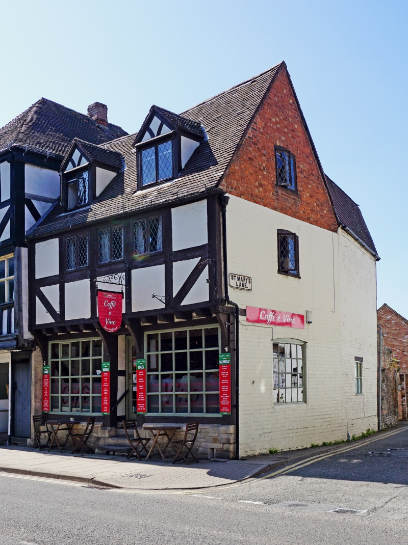
TEWKESBURY
SO8932 CHURCH STREET
859-1/6/144 (North side)
04/03/52 Nos.89 AND 90
GV II*
House at end of row, with shop, returns to St Mary's Street.
C15 or early C16 and C20. Braced timber-framing in large
square panels, brick return, stone plinth, tile roof, brick
stack.
PLAN: formerly described as being entirely encased in brick,
the parallel-plan property was substantially rebuilt with new
framing in the 1970s, but stands over a vaulted cellar of
early date.
EXTERIOR: 2 storeys, attic and cellar; 2 gabled dormers above
three 2-light casements in 3 adjacent wall panels, multi-pane
shop front with recessed central door on 4 stone steps. Plinth
wall, upper part of basement, reads as stall riser to windows,
contains upper part of slit light to right. Jettied upper
floor, corner bracket.
Right return has 2-light casements to attic and first floor,
in segmental heads, and multi-pane fixed light to ground
floor. Short gabled wing slightly canted to follow street
line. Stack to rear.
INTERIOR rebuilt to historic pattern with good timbers, but
substantially now of C20. Nine steep stone steps descend to
basement with concrete floor, rubble walls, and quadripartite
vault to deep (approx 225mm) broad-chamfered ribs with narrow
(approx 30mm) arris, rough cut stone to severies in English
mode. At the stair entry is a further narrow tranche of
vaulting, with a rib rising from the front wall and dying to
stone wall. Vault ribs rise from carved corbels at stair end.
Centre front is trimmed opening, and beginning of flight of
steps to pavement - now sealed, also, opposite stair, deep
embrasure to slit window in dressed stone. The vault form
suggests a continuation under the adjacent road (St Mary's
Street), but excavation at the time of restructuring did not
confirm this.
Important for retention of the stone cellar.
Listing NGR: SO8918032606
External links are from the relevant listing authority and, where applicable, Wikidata. Wikidata IDs may be related buildings as well as this specific building. If you want to add or update a link, you will need to do so by editing the Wikidata entry.


Other nearby listed buildings
