Latitude: 53.4039 / 53°24'14"N
Longitude: -3.08 / 3°4'47"W
OS Eastings: 328296
OS Northings: 390220
OS Grid: SJ282902
Mapcode National: GBR 6YX2.ZH
Mapcode Global: WH761.NPKV
Plus Code: 9C5RCW3C+H2
Entry Name: Church Farmhouse
Listing Date: 29 July 1950
Grade: II
Source: Historic England
Source ID: 1201586
English Heritage Legacy ID: 389230
ID on this website: 101201586
Location: Bidston, Wirral, Merseyside, CH43
County: Wirral
Electoral Ward/Division: Bidston and St James
Parish: Non Civil Parish
Built-Up Area: Birkenhead
Traditional County: Cheshire
Lieutenancy Area (Ceremonial County): Merseyside
Church of England Parish: Bidston St Oswald
Church of England Diocese: Chester
Tagged with: Farmhouse
This list entry was subject to a Minor Amendment on 17/07/2014
SJ2890
789-1/6/168
BIRKENHEAD
Bidston Village Road (South side)
Bidston
Church Farmhouse
(Formerly listed under HOYLAKE ROAD)
29/07/50
GV
II
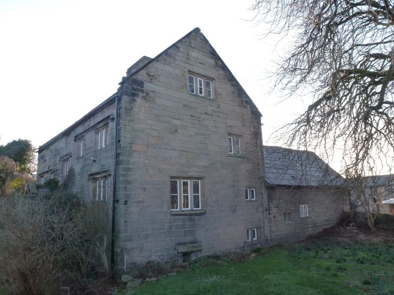
Farmhouse. Original building probably early C16, but main structure substantially early C17, though built in several phases. Coursed and squared stone with heavy slate roof. 3 storeys, 3-unit plan, with irregular internal layout and little consistency of level.Original build now forms rear wing. Main range with very irregular fenestration is C17, built in two phases, the earlier section comprising the 2 right-hand bays. Blocked doorway towards the right, with chamfered archway. 4-light mullioned window with hood mould
alongside it. Two 3-light mullioned windows with hood moulds above on different levels, and mullioned windows of 2- and 3-lights in attic storey with a continuous hood mould. Axial stack and coped gable. Left hand section has doorway to right in coped gabled porch with 3-light mullioned window with hood mould to left. 2- and 3-light mullioned windows above beneath continuous hood mould. Single 2-light window to attic storey. Plain chamfered mullions throughout, and hollow chamfers to hood moulds. Rear elevation stuccoed with some exposed brickwork. Parallel wing projecting to right added in C19. Lower left hand wing possibly forms part of earliest building on site. Coursed and squared rubble over cruck frame with slate roof. Wide doorway in gable end partially filled in, with inserted window over, and mullioned windows in west elevation. Cruck frame visible internally with 2 collars and 2 purlins.
Listing NGR: SJ2829690220
External links are from the relevant listing authority and, where applicable, Wikidata. Wikidata IDs may be related buildings as well as this specific building. If you want to add or update a link, you will need to do so by editing the Wikidata entry.


Other nearby listed buildings