Approximate Location Map
Large Map »
Latitude: 51.4578 / 51°27'28"N
Longitude: -2.5903 / 2°35'24"W
OS Eastings: 359085
OS Northings: 173372
OS Grid: ST590733
Mapcode National: GBR C9J.47
Mapcode Global: VH88N.1MZ8
Plus Code: 9C3VFC55+4V
Entry Name: Lower Arcade
Listing Date: 8 January 1959
Grade: II*
Source: Historic England
Source ID: 1202024
English Heritage Legacy ID: 379022
ID on this website: 101202024
Location: Kingsdown, Bristol, BS1
County: City of Bristol
Electoral Ward/Division: Central
Parish: Non Civil Parish
Built-Up Area: Bristol
Traditional County: Gloucestershire
Lieutenancy Area (Ceremonial County): Bristol
Church of England Parish: Bristol St Stephen with St James and St John the Baptist with St Michael and St George
Church of England Diocese: Bristol
Tagged with: Arcade
BRISTOL
ST5973 BROADMEAD, Broadmead
901-1/40/479 (North side)
08/01/59 Nos.1-36 (Consecutive)
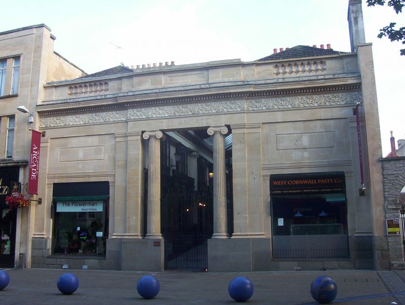
Lower Arcade
GV II*
Arcade. 1824-5. By Foster and Oakley. Limestone and Pennant
ashlar. Single-depth plan shops flanking an axial arcade.
Greek Revival style. Each shop of 2 storeys; 2-window range.
Broadmead front has a Pennant plinth below fluted Ionic
columns in antis; pilasters flank plate-glass shop fronts
either side, below panels, entablature with a dentil cornice,
a frieze of palmettes and parapet with half-blind balusters.
INTERIOR: columns to an entablature and cast-iron frieze
divide the arcade into 9 bays, with a glazed roof divided by
panelled sections with lion heads. A fine surviving example of
an early shopping arcade, modelled on the Burlington Arcade,
Piccadilly, London, and at 600 feet in length, rivalling
contemporary arcades in Cheltenham, Bath and London.
Originally in 2 sections, the Upper Arcade was destroyed in
1940.
(Gomme A, Jenner M and Little B: Bristol, An Architectural
History: Bristol: 1979-: 241).
Listing NGR: ST5908573372
External links are from the relevant listing authority and, where applicable, Wikidata. Wikidata IDs may be related buildings as well as this specific building. If you want to add or update a link, you will need to do so by editing the Wikidata entry.


Other nearby listed buildings
