Latitude: 51.4939 / 51°29'37"N
Longitude: -2.6167 / 2°37'0"W
OS Eastings: 357279
OS Northings: 177396
OS Grid: ST572773
Mapcode National: GBR C33.6B
Mapcode Global: VH88F.LQH4
Plus Code: 9C3VF9VM+H8
Entry Name: 38, Church Road
Listing Date: 3 June 1976
Last Amended: 30 December 1994
Grade: II*
Source: Historic England
Source ID: 1202079
English Heritage Legacy ID: 379172
ID on this website: 101202079
Location: Westbury on Trym, Bristol, BS9
County: City of Bristol
Electoral Ward/Division: Westbury-on-Trym and Henleaze
Parish: Non Civil Parish
Built-Up Area: Bristol
Traditional County: Gloucestershire
Lieutenancy Area (Ceremonial County): Bristol
Church of England Parish: Westbury-on-Trym
Church of England Diocese: Bristol
Tagged with: Building
BRISTOL
ST5777 CHURCH ROAD, Westbury On Trym
901-1/26/2046 (South side)
03/06/76 No.38
(Formerly Listed as:
CHURCH ROAD, Westbury
Nos.38 AND 39)
GV II*
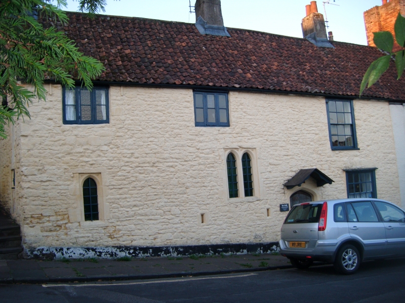
House. C15, partly refaced and extended C18. Rubble with
central and gable-end stacks and a pantile roof. Single-depth
plan with through passage. 2 storeys; 3-window range.
Chamfered Tudor-arched timber doorway to right of central
stack has a door of 4 studded planks, plain strap hinges and a
wrought-iron bishop's cross; C15 paired lancet windows with
label mould to the left and a single lancet to the right; C18
8/8-pane ground-floor, and 6/6-pane first-floor sashes, and
two C19 three-light casements under the eaves to the left. 2
small rectangular recesses with chamfered sides approx 1m from
the ground, to left of door.
INTERIOR: C15 or earlier arch-braced collar beam roof with
stages of wind bracing, a large corbel for the principal
truss, post and panel framing on the ground floor, a central
fireplace with stone cheeks and a deep stone bressumer, heavy
wood locks to door and a C19 stair to left of the door against
the front wall. An important survival, probably linked with
the adjacent Church of the Holy Trinity (qv).
Listing NGR: ST5728177394
External links are from the relevant listing authority and, where applicable, Wikidata. Wikidata IDs may be related buildings as well as this specific building. If you want to add or update a link, you will need to do so by editing the Wikidata entry.


Other nearby listed buildings