Latitude: 55.3097 / 55°18'34"N
Longitude: -1.9129 / 1°54'46"W
OS Eastings: 405623
OS Northings: 601736
OS Grid: NU056017
Mapcode National: GBR H721.NF
Mapcode Global: WHB0Q.LS8W
Plus Code: 9C7W835P+VR
Entry Name: Turks Head Inn
Listing Date: 25 August 1987
Grade: II
Source: Historic England
Source ID: 1203235
English Heritage Legacy ID: 236637
Also known as: Turks Head Hotel, Morpeth
ID on this website: 101203235
Location: Rothbury, Northumberland, NE65
County: Northumberland
Civil Parish: Rothbury
Built-Up Area: Rothbury
Traditional County: Northumberland
Lieutenancy Area (Ceremonial County): Northumberland
Church of England Parish: Upper Coquetdale
Church of England Diocese: Newcastle
Tagged with: Inn
ROTHBURY HIGH STREET NU 0501 (North side) 25/291 Turk's Head Inn GV II
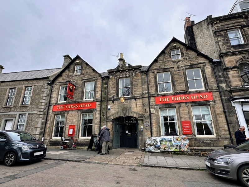
Inn. Rebuilt 1874 after fire; late C17 or early C18 rear wing. Main part tooled stone with rock-faced plinth and cut dressings; rear wing large rubble. Welsh slate roof except for pantiles on end part of rear wing. 2 storeys + attics, 2 + 1 + 2 bays. Chamfered plinth, sill bands. Gabled 2-bay outer sections with diamond-rusticated end pilasters, have 4-pane sash windows in moulded raised stone surrounds, including smaller central attic window in gable. Slightly-recessed centre has half-glazed double doors under segmental arch with broach-stopped chamfered jambs, moulded imposts, rusticated voussoirs and carved keystone with date on rear face; 4-pane sash above and raised shaped parapet on moulded corbels, with central bust of Turk. Stepped-and- corniced left end and ridge stacks; right end stack heightened with C20 brick top. Wing to rear right refenestrated in C19; end gable shows pigeon hole with alighting band and raised reverse-stepped coping.
Small rendered extension to rear left is not of special interest.
Listing NGR: NU0562301736
External links are from the relevant listing authority and, where applicable, Wikidata. Wikidata IDs may be related buildings as well as this specific building. If you want to add or update a link, you will need to do so by editing the Wikidata entry.


Other nearby listed buildings