Approximate Location Map
Large Map »
Latitude: 51.3844 / 51°23'3"N
Longitude: 1.3841 / 1°23'2"E
OS Eastings: 635567
OS Northings: 170479
OS Grid: TR355704
Mapcode National: GBR WZZ.2RV
Mapcode Global: VHLG6.YG3J
Plus Code: 9F3399MM+QJ
Entry Name: 24 and 26, Charlotte Square
Listing Date: 22 February 1973
Grade: II
Source: Historic England
Source ID: 1203430
English Heritage Legacy ID: 356519
ID on this website: 101203430
Location: Margate, Thanet, Kent, CT9
County: Kent
District: Thanet
Electoral Ward/Division: Margate Central
Parish: Non Civil Parish
Built-Up Area: Margate
Traditional County: Kent
Lieutenancy Area (Ceremonial County): Kent
Tagged with: Building
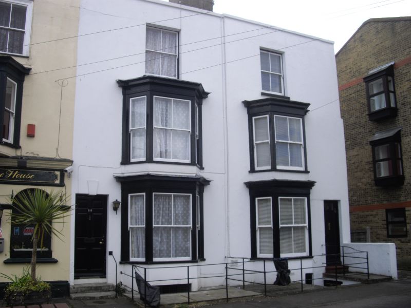
CHARLOTTE SQUARE
1.
1380
(South West Side)
Nos 24 and 26
TR 3570 SE 5/132
II GV
2.
Mid C19. 3 storeys and basement stuccoed. Tiled roof. Coping. 1 2nd floor
sash each and 3 light bays through other floors. Simple doorcases. No 26
has a 6 panelled door.
Nos 24 to 32 (even) form a group
Listing NGR: TR3556770479
External links are from the relevant listing authority and, where applicable, Wikidata. Wikidata IDs may be related buildings as well as this specific building. If you want to add or update a link, you will need to do so by editing the Wikidata entry.


Other nearby listed buildings
