Approximate Location Map
Large Map »
Latitude: 50.9156 / 50°54'56"N
Longitude: -1.2702 / 1°16'12"W
OS Eastings: 451402
OS Northings: 113154
OS Grid: SU514131
Mapcode National: GBR 87V.HPL
Mapcode Global: FRA 867P.70S
Plus Code: 9C2WWP8H+6W
Entry Name: 19, Winchester Street
Listing Date: 14 February 1983
Grade: II
Source: Historic England
Source ID: 1203631
English Heritage Legacy ID: 354894
ID on this website: 101203631
Location: Botley, Eastleigh, Hampshire, SO30
County: Hampshire
District: Eastleigh
Civil Parish: Botley
Built-Up Area: Hedge End
Traditional County: Hampshire
Lieutenancy Area (Ceremonial County): Hampshire
Church of England Parish: Botley All Saints
Church of England Diocese: Portsmouth
Tagged with: Building
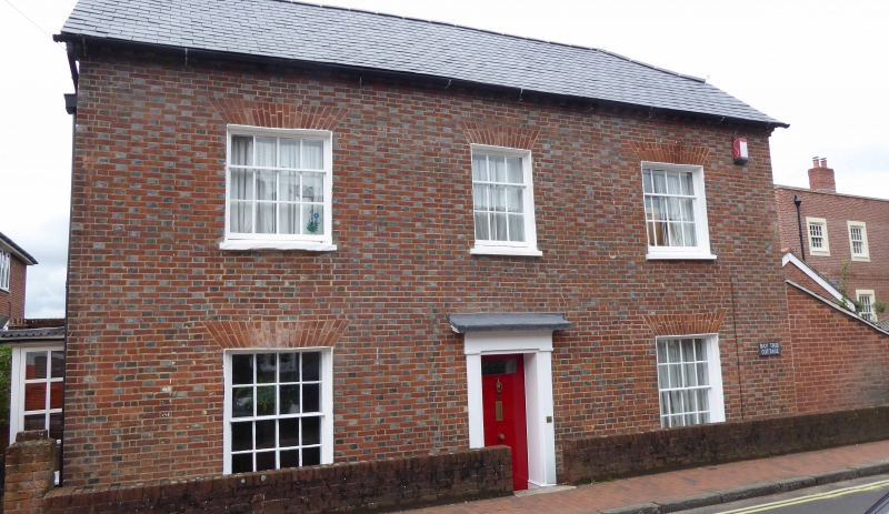
1.
5230 BOTLEY WINCHESTER STREET
(west side)
No 19
SU 5113 SW 9/49
II
2.
Early C19, 2 storeys, 3 windows. Slate (formerly tiled?) roof with half-hips, gable
to second rearward roof, brick dentil eaves. Brick walling in Flemish bond (blue
headers) with red rubbers to flat arches. Good sashes in reveals. Simple doorcase;
cornice and pilasters.
Listing NGR: SU5139913154
External links are from the relevant listing authority and, where applicable, Wikidata. Wikidata IDs may be related buildings as well as this specific building. If you want to add or update a link, you will need to do so by editing the Wikidata entry.


Other nearby listed buildings
