Approximate Location Map
Large Map »
Latitude: 51.2668 / 51°16'0"N
Longitude: 0.2745 / 0°16'28"E
OS Eastings: 558772
OS Northings: 154416
OS Grid: TQ587544
Mapcode National: GBR MN7.J66
Mapcode Global: VHHPT.PFY7
Plus Code: 9F32778F+PQ
Entry Name: Fir Tree House
Listing Date: 3 May 1984
Grade: II
Source: Historic England
Source ID: 1203936
English Heritage Legacy ID: 357255
ID on this website: 101203936
Location: Ivy Hatch, Tonbridge and Malling, Kent, TN15
County: Kent
District: Tonbridge and Malling
Civil Parish: Ightham
Built-Up Area: Ightham
Traditional County: Kent
Lieutenancy Area (Ceremonial County): Kent
Church of England Parish: Ightham St Peter
Church of England Diocese: Rochester
Tagged with: House
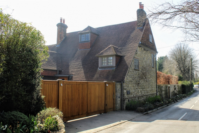
TQ 55 NE IGHTHAM ISMAYS ROAD
3/5 (east side)
Fir Tree House
II
House. C18. Coursed and galletted rubble stone. Eaves cornice to plain tiled roof-
with end stacks and 2 hipped dormers. Catslide to rear. Two storeys; 3 windows,
casements with cross transom and mullions. Central gabled porch with panelled door.
Listing NGR: TQ5877254416
External links are from the relevant listing authority and, where applicable, Wikidata. Wikidata IDs may be related buildings as well as this specific building. If you want to add or update a link, you will need to do so by editing the Wikidata entry.


Other nearby listed buildings
