Latitude: 53.6564 / 53°39'23"N
Longitude: -2.6935 / 2°41'36"W
OS Eastings: 354264
OS Northings: 417994
OS Grid: SD542179
Mapcode National: GBR 9VM5.N0
Mapcode Global: WH866.LCL8
Plus Code: 9C5VM844+HJ
Entry Name: Armestriding Farmhouse
Listing Date: 17 April 1967
Grade: II
Source: Historic England
Source ID: 1204225
English Heritage Legacy ID: 357622
ID on this website: 101204225
Location: Chorley, Lancashire, PR7
County: Lancashire
District: Chorley
Civil Parish: Euxton
Traditional County: Lancashire
Lieutenancy Area (Ceremonial County): Lancashire
Church of England Parish: Euxton
Church of England Diocese: Blackburn
Tagged with: Farmhouse
SD 51 NE EUXTON off DAWBER'S LANE
4/105 Armetriding Farmhouse
17.4.1967
- II
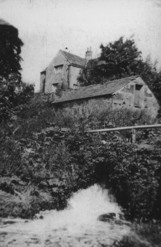
Farmhouse, dated 1570, with later wing. Coursed sandstone rubble and
limewashed scored render; stone slate roof with one chimney on the
ridge and another at the rear gable (both brick). T-shaped plan, both
elements of 2-bays. Two storeys, front and back doors now in rear
wing close to junction; this wing is unrendered sandstone and all openings
are C18 or C19. The element of principal interest is the present
crosswing which has in the front and rear gables one stone mullioned
window on each floor, all of 5-lights with deeply splayed reveals,
ovolo-moulded mullions, and hoodmoulds; left return wall has a single-
storey lean-to (with a 2-light stone mullioned window at the front),
covering a central door, a 3-light stone mullioned window above it;
to the left is a 2-light mullioned window and at 1st floor a 3-light
window with unusual triple-moulded jambs, head and mullions, and a
hoodmould; beneath this window is a datestone lettered in relief:
1570 . HA
AoDMI
Interior: wing has some beams with stopped rounded-moulding, and at
1st floor one altered arch-braced roof truss with a doorway inserted
in the centre.
Listing NGR: SD5426417994
External links are from the relevant listing authority and, where applicable, Wikidata. Wikidata IDs may be related buildings as well as this specific building. If you want to add or update a link, you will need to do so by editing the Wikidata entry.


Other nearby listed buildings