Approximate Location Map
Large Map »
Latitude: 51.2528 / 51°15'10"N
Longitude: 0.3202 / 0°19'12"E
OS Eastings: 562015
OS Northings: 152962
OS Grid: TQ620529
Mapcode National: GBR NPT.HS4
Mapcode Global: VHHPV.HRNZ
Plus Code: 9F32783C+43
Entry Name: Makefeyres
Listing Date: 3 May 1984
Grade: II
Source: Historic England
Source ID: 1204727
English Heritage Legacy ID: 357364
ID on this website: 101204727
Location: Roughway, Tonbridge and Malling, Kent, TN11
County: Kent
District: Tonbridge and Malling
Civil Parish: Plaxtol
Traditional County: Kent
Lieutenancy Area (Ceremonial County): Kent
Church of England Parish: Plaxtol
Church of England Diocese: Rochester
Tagged with: Barn
This list entry was subject to a Minor Amendment on 16/09/2019
TQ 65 SW
4/33
PLAXTOL
ROUGHWAY LANE (south side)
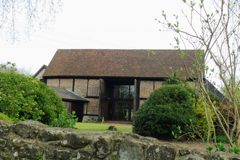
Makefeyres
(formerly listed as Barn 30 yds to the east of Lower Roughway Farmhouse)
GV
II
Barn. C17. Exposed box-frame construction with brick infill, some diagonal. Plain tiled roof with lean-to at west end. Weather-boarded north waggon entrance. Five bays.
Listing NGR: TQ6187653001
External links are from the relevant listing authority and, where applicable, Wikidata. Wikidata IDs may be related buildings as well as this specific building. If you want to add or update a link, you will need to do so by editing the Wikidata entry.


Other nearby listed buildings
