Approximate Location Map
Large Map »
Latitude: 53.2602 / 53°15'36"N
Longitude: -2.125 / 2°7'29"W
OS Eastings: 391760
OS Northings: 373695
OS Grid: SJ917736
Mapcode National: GBR FZLR.R0
Mapcode Global: WHBBP.BBC0
Plus Code: 9C5V7V6G+32
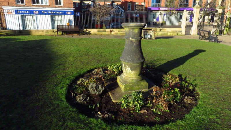
Entry Name: Sundial in Churchyard of Church of St Michael
Listing Date: 17 March 1977
Grade: II
Source: Historic England
Source ID: 1206934
English Heritage Legacy ID: 391048
ID on this website: 101206934
Location: Macclesfield, Cheshire East, Cheshire, SK10
County: Cheshire East
Civil Parish: Macclesfield
Built-Up Area: Macclesfield
Traditional County: Cheshire
Lieutenancy Area (Ceremonial County): Cheshire
Church of England Parish: St Michael and All Angels, Macclesfield
Church of England Diocese: Chester
Tagged with: Sundial
MACCLESFIELD
SJ9173NE MARKET PLACE
886-1/10/140 (East side)
17/03/77 Sundial in churchyard of Church of
St Michael
GV II
Sundial. Probably C18. Baluster-pedestal on stone base, the
dial now missing.
Listing NGR: SJ9176173692
External links are from the relevant listing authority and, where applicable, Wikidata. Wikidata IDs may be related buildings as well as this specific building. If you want to add or update a link, you will need to do so by editing the Wikidata entry.


Other nearby listed buildings
