Approximate Location Map
Large Map »
Latitude: 54.9042 / 54°54'14"N
Longitude: -1.3814 / 1°22'52"W
OS Eastings: 439765
OS Northings: 556779
OS Grid: NZ397567
Mapcode National: GBR VCS.4S
Mapcode Global: WHD55.RZDS
Plus Code: 9C6WWJ39+MF
Entry Name: Burdon House
Listing Date: 17 October 1994
Grade: II
Source: Historic England
Source ID: 1207060
English Heritage Legacy ID: 391395
ID on this website: 101207060
Location: Sunderland, Tyne and Wear, SR1
County: Sunderland
Electoral Ward/Division: St Michael's
Parish: Non Civil Parish
Built-Up Area: Sunderland
Traditional County: Durham
Lieutenancy Area (Ceremonial County): Tyne and Wear
Church of England Parish: Millfield St Mark
Church of England Diocese: Durham
Tagged with: House
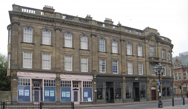
SUNDERLAND
NZ3956NE BURDON ROAD
920-1/20/23 (West side)
Nos.1-4 (Consecutive)
Burdon House
GV II
Shops and offices. 1916. For North Eastern Railway. Ashlar;
roof not visible; ashlar chimneys. 3 storeys, 10x3 windows.
Rusticated ground floor has pilasters framing door in 9th bay
under high overlight, in round-headed surround with hollow
reveals, and supporting shop entablature with fascia name
boards. Giant pilasters to upper floors rest on moulded
brackets and frame pairs of sashes, the lower in architraves,
the upper with keyed segmental-headed architraves on moulded
sills with plain rectangular aprons. Top entablature with
dentilled cornice supports balustraded roof parapet.
Low-pitched roof has corniced end ashlar chimneys. Right
return similar. Left return has central 3-light mullioned and
transomed windows flanked by 2-storey shallow bow tripartite
oriels.
(Corfe T: The Buildings of Sunderland 1814-1914: Newcastle:
1983-: 19; Sinclair NT: Railways of Sunderland: Newcastle upon
Tyne: 1986-: 22).
Listing NGR: NZ3976556778
External links are from the relevant listing authority and, where applicable, Wikidata. Wikidata IDs may be related buildings as well as this specific building. If you want to add or update a link, you will need to do so by editing the Wikidata entry.


Other nearby listed buildings
