Approximate Location Map
Large Map »
Latitude: 53.3754 / 53°22'31"N
Longitude: -1.0522 / 1°3'8"W
OS Eastings: 463150
OS Northings: 386923
OS Grid: SK631869
Mapcode National: GBR PY2D.ZQ
Mapcode Global: WHFG0.TF46
Plus Code: 9C5W9WGX+54
Entry Name: Mill Farmhouse and Attached Walls and Outhouses
Listing Date: 27 November 1984
Grade: II
Source: Historic England
Source ID: 1207584
English Heritage Legacy ID: 241079
ID on this website: 101207584
Location: Blyth, Bassetlaw, Nottinghamshire, S81
County: Nottinghamshire
District: Bassetlaw
Civil Parish: Blyth
Built-Up Area: Blyth
Traditional County: Nottinghamshire
Lieutenancy Area (Ceremonial County): Nottinghamshire
Church of England Parish: Blyth
Church of England Diocese: Southwell and Nottingham
Tagged with: Farmhouse
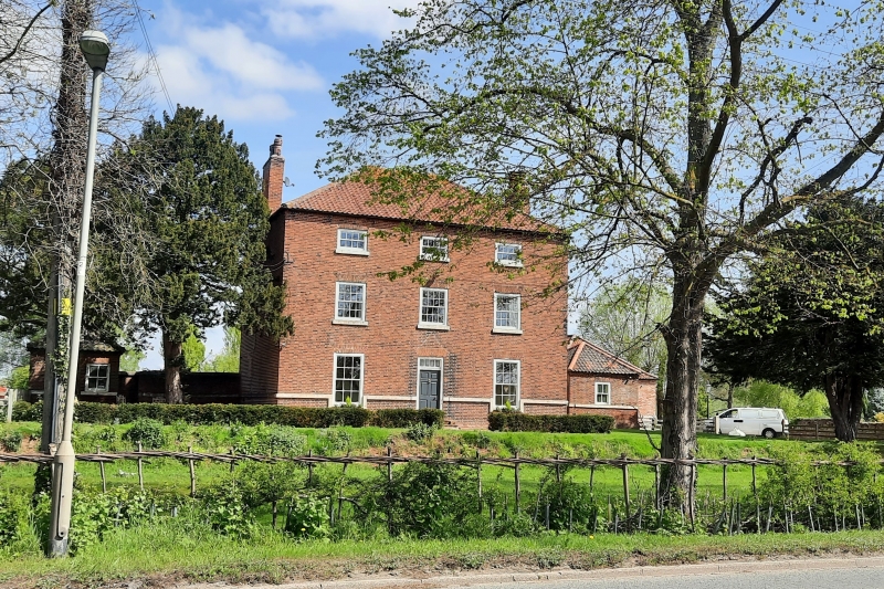
SK 68 NW BLYTH RETFORD ROAD
(north side)
2/51 Mill Farmhouse
and attached walls
and outhouses
II
Farmhouse. Late C18. Red brick under a hipped pantile roof,
with 2 brick gable stacks and dog tooth eaves. 2.1/2 storeys, 3
bays. Set on a plinth with ground floor sill band. Central
doorway with panelled door and glazing bar overlight, having
wooden moulded surround. With late C19 iron trellis tent canopy.
To the left a glazing bar sash and to the right a C20 glazing bar
casement in original opening, with 3 similar casements on the 1st
floor and 3 similar smaller casements above. Either side of the
house, to the rear, are single stone coped brick walls with band
continuing from the house. The walls terminate in single square
red brick outhouses with pyramidal pantile roofs and dog tooth
eaves. The band continues along the outhouses. Each has a
single glazing bar sash, that to the right was formerly the wash-
house.
Listing NGR: SK6315086923
External links are from the relevant listing authority and, where applicable, Wikidata. Wikidata IDs may be related buildings as well as this specific building. If you want to add or update a link, you will need to do so by editing the Wikidata entry.


Other nearby listed buildings
