Latitude: 52.6279 / 52°37'40"N
Longitude: -2.4856 / 2°29'7"W
OS Eastings: 367230
OS Northings: 303461
OS Grid: SJ672034
Mapcode National: GBR BW.7GSW
Mapcode Global: WH9DG.S6LQ
Plus Code: 9C4VJGH7+5Q
Entry Name: 11, Tontine Hill
Listing Date: 9 August 1974
Last Amended: 8 April 1983
Grade: II
Source: Historic England
Source ID: 1207855
English Heritage Legacy ID: 362216
ID on this website: 101207855
Location: Ironbridge, Telford and Wrekin, Shropshire, TF8
County: Telford and Wrekin
Civil Parish: The Gorge
Built-Up Area: Telford
Traditional County: Shropshire
Lieutenancy Area (Ceremonial County): Shropshire
Church of England Parish: Ironbridge
Church of England Diocese: Hereford
Tagged with: Building
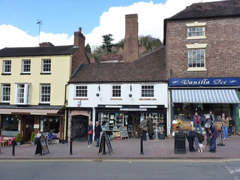
IRONBRIDGE TONTINE HILL
1.
5362 No 11
(Formerly listed as
No 2 Tontine Hill)
SJ 6703 SW 15/361 9.8.74
II GV
2.
Circa C18. Stucco with plain tile roof. Two storeys. Two wooden casements to
first floor, shop front with plate-glass windows and central door to ground floor.
Salient feature is tall brick chimney stack rising from rear.
Listing NGR: SJ6723003461
External links are from the relevant listing authority and, where applicable, Wikidata. Wikidata IDs may be related buildings as well as this specific building. If you want to add or update a link, you will need to do so by editing the Wikidata entry.


Other nearby listed buildings