Latitude: 54.0465 / 54°2'47"N
Longitude: -2.901 / 2°54'3"W
OS Eastings: 341099
OS Northings: 461543
OS Grid: SD410615
Mapcode National: GBR 8P5N.Q6
Mapcode Global: WH845.DKS8
Plus Code: 9C6V23WX+HH
Entry Name: The Royal Hotel Including Adjoining Outbuildings
Listing Date: 29 December 1950
Last Amended: 20 January 1993
Grade: II
Source: Historic England
Source ID: 1208942
English Heritage Legacy ID: 391829
ID on this website: 101208942
Location: Lower Heysham, Lancaster, Lancashire, LA3
County: Lancashire
District: Lancaster
Electoral Ward/Division: Heysham Central
Parish: Non Civil Parish
Built-Up Area: Heysham
Traditional County: Lancashire
Lieutenancy Area (Ceremonial County): Lancashire
Church of England Parish: Heysham St Peter
Church of England Diocese: Blackburn
Tagged with: Hotel
MORECAMBE AND HEYSHAM
SD4161 MAIN STREET, Heysham 939-1/7/26 (West side) 29/12/50 No.9 The Royal Hotel, including adjoining outbuildings (Formerly Listed as: MAIN STREET No.9 The Royal Hotel)
GV II
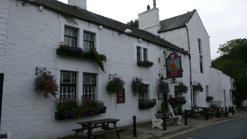
Public house. Probably mid C18 with late C18 and early C19 additions. Roughcast and painted rubble with slate roofs. Main building 2 storeys and 3 bays. Windows have glazing bars and are a mixture of sashes and casements. All have plain stone surrounds with a central flat-faced mullion, except for the ground-floor windows to bays 2 and 3 which have had their mullions removed. The door, between the 2nd and 3rd bays, has a stone surround with a narrow chamfer. Chimneys to left and right and between 1st and 2nd bays. At the right is a former warehouse, of 3 storeys with its gable facing the road. It has a door at the left with chamfered stone surround and a window to its right with plain reveals. Above, rising through the 1st and 2nd floors, is a former loading door with plain reveals and with glazing bar sashes separated by a transom. Adjoining to the right is a former barn which has a cart entrance with segmental arch, a door at the left with plain reveals, and a mid C20 shop front inserted at the right. To the left of the main building is another former farm building which has a cart entrance with segmental arch, and a door with plain reveals to the left. To the right is one bay of living accommodation which has C20 casement windows with glazing bars with plain stone surrounds, a door to the right with similar surround, and a chimney to the left. At the rear of this former farm building is a wing of exposed rubble which was probably once two houses but is now disused and has 2 bays facing south with plain stone surrounds, and a re-used C17 three-light mullioned window in its west gable.
Listing NGR: SD4109961543
External links are from the relevant listing authority and, where applicable, Wikidata. Wikidata IDs may be related buildings as well as this specific building. If you want to add or update a link, you will need to do so by editing the Wikidata entry.


Other nearby listed buildings