Latitude: 50.5757 / 50°34'32"N
Longitude: -1.2979 / 1°17'52"W
OS Eastings: 449812
OS Northings: 75339
OS Grid: SZ498753
Mapcode National: GBR 8CW.W43
Mapcode Global: FRA 875J.VL1
Plus Code: 9C2WHPG2+7R
Entry Name: St Catherine's Lighthouse
Listing Date: 18 January 1967
Grade: II
Source: Historic England
Source ID: 1209275
English Heritage Legacy ID: 392863
ID on this website: 101209275
Location: Isle of Wight, PO38
County: Isle of Wight
Civil Parish: Niton and Whitwell
Traditional County: Hampshire
Lieutenancy Area (Ceremonial County): Isle of Wight
Church of England Parish: Niton St John the Baptist
Church of England Diocese: Portsmouth
Tagged with: Lighthouse
NITON AND WHITWELL
SZ47NE ST CATHERINE'S ROAD (OFF) 1353-0/5/233 St Catherine's Lighthouse 18/01/67
GV II
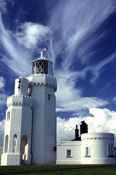
Lighthouse. Built 1838-40. Designed by Walker and Burgess and altered in 1875 when, on account of mist the height was reduced to 86 feet by the removal of the upper stage and part of the middle stage. Stuccoed octagonal tower of 2 stages. Machicolations and castellated parapet surmounted by conical light and ball finial and weathervane. In 1932 a lower tower of 2 storeys, reproducing the design of the main lighthouse as shortened, but with an open arcade on the ground floor, was added on the south side to mount the foghorn. These 2 towers are known locally as the Cow and the Calf. To the west of the main Lighthouse tower is a doorway with the date 1838 over it and a projection on the ground floor with gable above. Attached to the east is the Head Lighthouse keeper's house of 1 storey with curved front and round headed window facing east. This lighthouse was one of the first in the world to be illuminated by electric light being fitted with it in 1888. This is the third lighthouse to be built, the lst being the old mediaeval pharos attached to St Catherine's Oratory, the 2nd being an unfinished lighthouse started in 1785 beside it but abandoned don account of dense mists. St Catherine's lighthouse was built as a result of the wreck of the 'Clarendon' in Chale Bay on the 11th October 1836.
Listing NGR: SZ4981275339
External links are from the relevant listing authority and, where applicable, Wikidata. Wikidata IDs may be related buildings as well as this specific building. If you want to add or update a link, you will need to do so by editing the Wikidata entry.


Other nearby listed buildings