Approximate Location Map
Large Map »
Latitude: 50.317 / 50°19'1"N
Longitude: -4.6731 / 4°40'23"W
OS Eastings: 209794
OS Northings: 49757
OS Grid: SX097497
Mapcode National: GBR N4.YKGD
Mapcode Global: FRA 1836.7UN
Plus Code: 9C2Q888G+QQ
Entry Name: Gribbin Tower
Listing Date: 11 March 1974
Grade: II
Source: Historic England
Source ID: 1210498
English Heritage Legacy ID: 395103
ID on this website: 101210498
Location: Cornwall, PL24
County: Cornwall
Civil Parish: Fowey
Traditional County: Cornwall
Lieutenancy Area (Ceremonial County): Cornwall
Church of England Parish: Tywardreath
Church of England Diocese: Truro
Tagged with: Tower
FOWEY
1. GRIBBIN HEAD
1584A
Gribbin Tower
SX 05 SE 10/178
II
2.
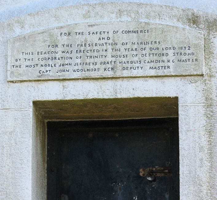
Built 1832, by Corporation of Trinity House of Deptford. Day navigation
beacon. Painted red and white stripes. Ashlar. Very tall tower, square
plan, slightly tapered. Topped by corbelled parapet. Narrow stair lights
on two sides. Doorway at base with plain architrave. Very prominent
landmark on Gribbin Head.
Listing NGR: SX0979449757
External links are from the relevant listing authority and, where applicable, Wikidata. Wikidata IDs may be related buildings as well as this specific building. If you want to add or update a link, you will need to do so by editing the Wikidata entry.


Other nearby listed buildings
