Approximate Location Map
Large Map »
Latitude: 54.7468 / 54°44'48"N
Longitude: -2.8198 / 2°49'11"W
OS Eastings: 347325
OS Northings: 539406
OS Grid: NY473394
Mapcode National: GBR 8FRK.95
Mapcode Global: WH80Q.NYFC
Plus Code: 9C6VP5WJ+P3
Entry Name: Boundary Stone South West of Calthwaite House
Listing Date: 24 October 1986
Grade: II
Source: Historic England
Source ID: 1210528
English Heritage Legacy ID: 73880
ID on this website: 101210528
Location: Calthwaite, Westmorland and Furness, Cumbria, CA11
County: Cumbria
District: Eden
Civil Parish: Hesket
Traditional County: Cumberland
Lieutenancy Area (Ceremonial County): Cumbria
Church of England Parish: Calthwaite All Saints
Church of England Diocese: Carlisle
Tagged with: Boundary marker
NY 43 NE HESKET CALTHWAITE
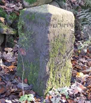
10/155 Boundary stone south-
west of Calthwaite
House
II
Roadside parish boundary stone. Early C19. Red sandstone. Square stone, with
pyramidal cap, set at angle. Inscribed on 2 faces CALTHWAITE and PLUMPTON.
Listing NGR: NY4732539406
External links are from the relevant listing authority and, where applicable, Wikidata. Wikidata IDs may be related buildings as well as this specific building. If you want to add or update a link, you will need to do so by editing the Wikidata entry.


Other nearby listed buildings
