Approximate Location Map
Large Map »
Latitude: 51.4901 / 51°29'24"N
Longitude: -0.6096 / 0°36'34"W
OS Eastings: 496628
OS Northings: 177715
OS Grid: SU966777
Mapcode National: GBR F8D.GPL
Mapcode Global: VHFT8.DT21
Plus Code: 9C3XF9RR+35
Entry Name: 134-137, High Street
Listing Date: 14 May 1973
Grade: II
Source: Historic England
Source ID: 1211447
English Heritage Legacy ID: 395926
ID on this website: 101211447
Location: Eton, Windsor and Maidenhead, Berkshire, SL4
County: Windsor and Maidenhead
Civil Parish: Eton
Built-Up Area: Eton
Traditional County: Buckinghamshire
Lieutenancy Area (Ceremonial County): Berkshire
Church of England Parish: Eton
Church of England Diocese: Oxford
Tagged with: Building
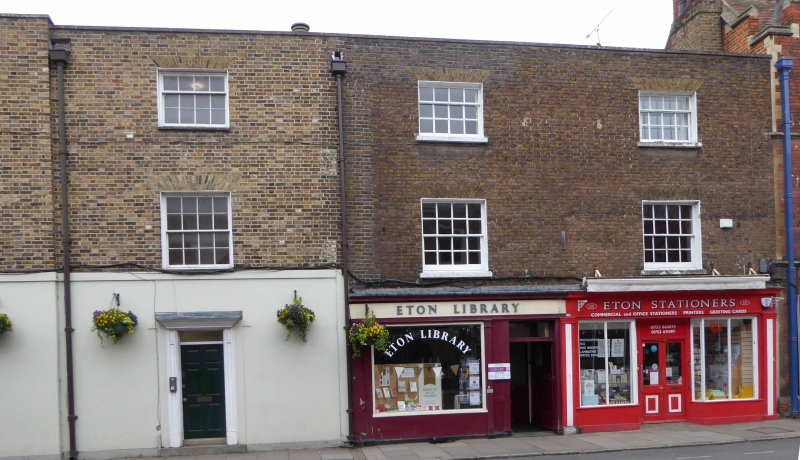
1. HIGH STREET
1909 (West Side)
Nos 134 to 137 (consec)
SU 9677 NE 1/75
II GV
2.
Early C19 row of houses. Yellow brick, roof parapet. 3 storeys, sash windows
in reveals under flat arches. Included for group value.
Nos 126 to 138 (consec) form a group.
Listing NGR: SU9662377719
External links are from the relevant listing authority and, where applicable, Wikidata. Wikidata IDs may be related buildings as well as this specific building. If you want to add or update a link, you will need to do so by editing the Wikidata entry.


Other nearby listed buildings
