Approximate Location Map
Large Map »
Latitude: 52.0222 / 52°1'19"N
Longitude: -1.0078 / 1°0'28"W
OS Eastings: 468176
OS Northings: 236435
OS Grid: SP681364
Mapcode National: GBR 9XH.411
Mapcode Global: VHDT2.HF1N
Plus Code: 9C4W2XCR+VV
Entry Name: New Inn Farmhouse with Outbuildings Behind
Listing Date: 21 April 1983
Last Amended: 15 April 2003
Grade: II*
Source: Historic England
Source ID: 1211787
English Heritage Legacy ID: 396303
ID on this website: 101211787
Location: Chackmore, Buckinghamshire, MK18
County: Buckinghamshire
Civil Parish: Stowe
Traditional County: Buckinghamshire
Lieutenancy Area (Ceremonial County): Buckinghamshire
Church of England Parish: Stowe
Church of England Diocese: Oxford
Tagged with: Farmhouse
STOWE
1129/3/97 NEW INN FARMHOUSE WITH OUTBUILDINGS BEHIND
21-APR-1983
(Formerly listed as:
NEW INN FARMHOUSE)
GV II*
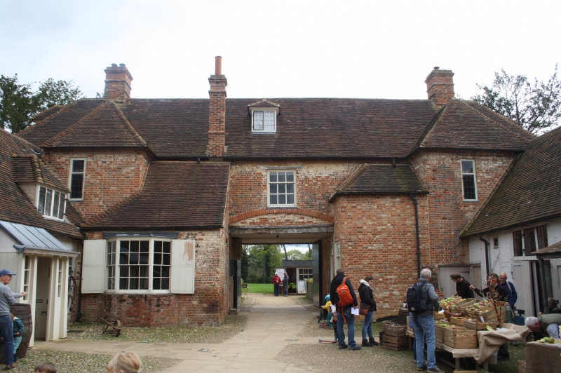
Former coaching inn, now farmhouse. 1717-19, with early-C19 alterations. Attributed to Thomas Harris of Cublington, foreman for Sir John Vanbrugh who co-ordinated the early building work at Stowe, and built for Lord Cobham. Front of chequered brick with moulded brick cornice and stringcourse. Hipped tiled roof with ridge chimneystacks to each end. 2 storeys and attic range with single storey range of outbuildings behind.
EXTERIOR: FRONT elevation of 5 bays with early-C19 sash windows, tripartite to central bays, ground floor and upper centre openings have brick cambered arches. 2 hipped dormers with 3-light leaded casements. Central carriage opening. REAR elevation to courtyard is much as it appears in an 1809 drawing, with advanced bays to each end with hipped roofs, to left a canted bay window with sashes. OUTBUILDINGS to left, the brewhouse with ridge stack and end stack, timberframing to gable end, and dairy to outside. To right, stable with outer wall of coursed ironstone. Outbuildings continue to rear with coach house, timber-framed with brick infill and brick, but dilapidated with roof collapse at time of re-inspection (November 2003).
INTERIOR: FARMHOUSE has entrance to each wing under carriage entrance through 6-panel door with overlight to a corridor. To left wing, stick baluster staircase. To right wing, rear room with bay window to courtyard has arched recess, ogee gothic arched cupboard, reeded chair rails and chimneypieces from early-C19 re-fitting. Service bell system in corridor. To right end, boxed-in stair. 4-panel and 6-panel doors with architeraves throughout. Heavy oak roof structure. OUTBUILDINGS include heavy open fireplace to stable range, fireplace to brewhouse, and low brick arches to dairy.
HISTORY: New Inn was built in 1717-19 for Viscount Cobham as part of his campaign to enlarge the mansion at Stowe and to create the extensive landscape, laid out by Charles Bridgeman with garden buildings by Sir John Vanbrugh. It is probably the first inn built for visitors to a house and garden, and is described repeatedly throughout the C18 and C19, not always favourably, in the visitors' letters and journals. In the 1860s when the garden closed to the public, New Inn became a farmhouse.
SOURCES: Bevington, Michael. Templa Quam Dilecta Number 1 The Grand Avenue, the Corinthian Arch and the Entrance Drives.
Bevington, Michael. Stowe House (2002).
Bevington, Michael. Stowe the Garden and Park (1994).
G.B. Clarke, Ed. Description of Lord Cobham's Gardens at Stowe (1700-1750). Buckingham Record Society No.26, 1990.
N. Pevsner and E. Williamson, The Buildings of England: Buckinghamshire (1994) p. 674.
B. Seeley. A Dialogue: containing a description of the garden of the rt. Hon. The Lord Viscount Cobham at Stow in Buckinghamshire. London, 1751.
c.1809 drawing by J.C. Nattes.
Group Value with the Grade I Registered Stowe Park, and the numerous listed buildings on the grounds, many of which are Grade I.
Listing NGR: SP6817636435
External links are from the relevant listing authority and, where applicable, Wikidata. Wikidata IDs may be related buildings as well as this specific building. If you want to add or update a link, you will need to do so by editing the Wikidata entry.


Other nearby listed buildings
