Approximate Location Map
Large Map »
Latitude: 53.6517 / 53°39'6"N
Longitude: -1.801 / 1°48'3"W
OS Eastings: 413252
OS Northings: 417262
OS Grid: SE132172
Mapcode National: GBR HVV6.WP
Mapcode Global: WHCB1.9GNW
Plus Code: 9C5WM52X+MJ
Entry Name: Gledholt Methodist Church
Listing Date: 29 September 1978
Last Amended: 6 March 1979
Grade: II
Source: Historic England
Source ID: 1211990
English Heritage Legacy ID: 339822
ID on this website: 101211990
Location: Marsh, Kirklees, West Yorkshire, HD1
County: Kirklees
Electoral Ward/Division: Greenhead
Parish: Non Civil Parish
Built-Up Area: Huddersfield
Traditional County: Yorkshire
Lieutenancy Area (Ceremonial County): West Yorkshire
Church of England Parish: Huddersfield Holy Trinity
Church of England Diocese: Leeds
Tagged with: Protestant church building
In the entry for EDGERTON GROVE ROAD
(West Side)
27/495
Marsh Methodist Church
Marsh Methodist Church shall be amended to read
Gledholt Methodist Church
------------------------------------
EDGERTON GROVE ROAD
1. (West Side)
5113 Marsh Fold
Marsh Methodist Church
SE 1317 27/495
II
2.
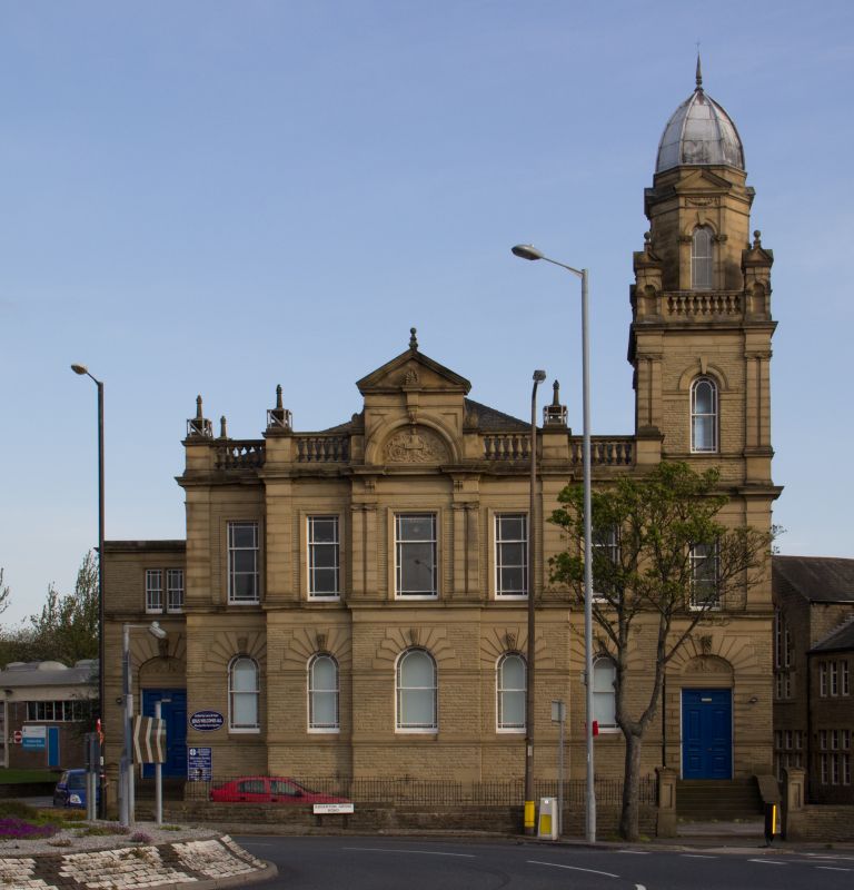
Mid C19. Rock-faced stone. Ashlar dressings. Hipped slate roof. 2 storeys.
Ground floor astylar with moulded cornice. Continuous moulded ground floor
impost band. Angle pilasters on 1st floor to full entablature and balustrade
with vase-shaped balusters: piers with urn finials. 5 ranges of sashes, those
on ground floor round-arched with rusticated ashlar voussoirs and moulded keystones,
those on 1st floor with moulded surrounds: marginal glazing bars. Centre 3
bays break forward. Central bay breaks forward again and on 1st floor has
paired Ionic pilasters to frame it. Above it an arch with sculpted tympanum,
moulded voussoirs and keystone, flanked by scrolled consoles and crowned by
triangular pediment.
One bay projections to east and west: ground floor as ground floor elsewhere
except they have double doors with fielded panels instead of windows and depressed
instead of round-arched heads. West projection is of 2 storeys, with one tripartite
sash with marginal glazing bars and ashlar frame on 1st floor. East projection
has 4 storey tower, each storey with full entablature. 1st floor has broad
angle pilasters and one sash with marginal glazing bars in moulded frame.
2nd floor has paired Ionic pilasters at angles and similar window: moulded
impost band. Balustrade with vase-shaped balusters. Angle turrets with round-arched
niches on each side, crowned by 4 steep pediments each. 3rd storey is octagonal.
Each side has one round-arched sash with marginal glazing bars, keystone, and
moulded voussoirs crowned at cornice level by triangular pediment. Octagonal
lead cupola with finial.
Listing NGR: SE1325217262
External links are from the relevant listing authority and, where applicable, Wikidata. Wikidata IDs may be related buildings as well as this specific building. If you want to add or update a link, you will need to do so by editing the Wikidata entry.


Other nearby listed buildings
