Latitude: 52.8055 / 52°48'19"N
Longitude: -2.1167 / 2°7'0"W
OS Eastings: 392229
OS Northings: 323116
OS Grid: SJ922231
Mapcode National: GBR 16X.5N9
Mapcode Global: WHBDT.GR82
Plus Code: 9C4VRV4M+68
Entry Name: 39, 39A and 40, Greengate Street
Listing Date: 16 January 1951
Last Amended: 16 February 1994
Grade: II
Source: Historic England
Source ID: 1212138
English Heritage Legacy ID: 383987
ID on this website: 101212138
Location: Stafford, Staffordshire, ST16
County: Staffordshire
District: Stafford
Electoral Ward/Division: Forebridge
Parish: Non Civil Parish
Built-Up Area: Stafford
Traditional County: Staffordshire
Lieutenancy Area (Ceremonial County): Staffordshire
Church of England Parish: Stafford St Mary
Church of England Diocese: Lichfield
Tagged with: Building
STAFFORD
SJ9223SW GREENGATE STREET 590-1/10/45 (West side) 16/01/51 Nos.39, 39A AND 40 (Formerly Listed as: GREENGATE STREET (West side) Nos.39 AND 40)
GV II
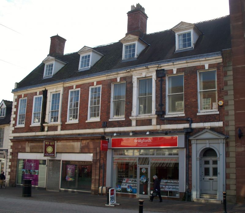
Two houses, now shop and office. Mid C18 with early C19 and later alterations. Brick with ashlar dressings; tile roof with coped gable and brick end and cross-axial stack. Early Georgian style. EXTERIOR: 2 storeys with attic; 9-window range. Platt band over ground floor and top cornice; quoins. 2 early C20 shopfronts; round-headed entrance to right end has early C19 doorcase with archivolt, pilaster strips, frieze and pediment; fanlight over 6-panel door. 1st floor has windows with rubbed brick flat arches and ashlar keys over 9/6-pane sashes in moulded frames to 5 windows to left, 4 windows to right have 2-panel horned sashes; 3rd window from each end has eared and shouldered architrave with key and moulded sill on blocks; 4 pedimented dormers with small-paned casements. 2 rainwater heads with cherubs in round arches, and square downspouts to 1st floor only. Rear has gabled wing and early C19 gabled range to left, with 2 gables to end with windows in architraves, friezes and pediments; return has windows with small-paned casements with intersecting glazing bars. INTERIOR: 1820s detailing; stair with slender balusters and wreathed handrail; room to rear with rich plaster cornice and marble fireplace; 2 lamp brackets to 1st floor corridor; left end has early C18 open well stair to 1st floor up, with spiral balusters, moulded and ramped handrail, cut string with moulded tread ends and bolection-moulded dado panelling; 3 contemporary 6-fielded-panel doors. Ground floor originally had 2 entrances with eared architraves and signs remain of keys to windows. (County Planning Department Photographic Collection).
Listing NGR: SJ9222823120
External links are from the relevant listing authority and, where applicable, Wikidata. Wikidata IDs may be related buildings as well as this specific building. If you want to add or update a link, you will need to do so by editing the Wikidata entry.


Other nearby listed buildings