Latitude: 51.7823 / 51°46'56"N
Longitude: -1.4858 / 1°29'8"W
OS Eastings: 435569
OS Northings: 209422
OS Grid: SP355094
Mapcode National: GBR 6VS.95L
Mapcode Global: VHC02.6GCH
Plus Code: 9C3WQGJ7+WM
Entry Name: Masonic Hall and Attached Outbuilding and Wall
Listing Date: 14 May 1952
Grade: II
Source: Historic England
Source ID: 1212242
English Heritage Legacy ID: 252626
ID on this website: 101212242
Location: Witney, West Oxfordshire, OX28
County: Oxfordshire
District: West Oxfordshire
Civil Parish: Witney
Built-Up Area: Witney
Traditional County: Oxfordshire
Lieutenancy Area (Ceremonial County): Oxfordshire
Church of England Parish: Witney
Church of England Diocese: Oxford
Tagged with: Masonic temple
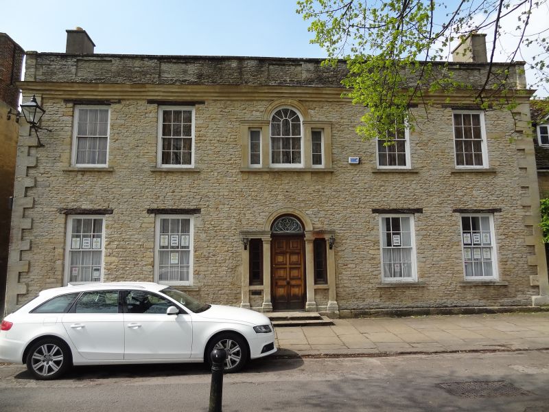
WITNEY CHURCH GREEN SP3509S (West side) 11/32 No.20 (Masonic Hall), and 14/05/52 attached outbuilding and wall GV II
House, c.1760. Coursed limestone rubble with raised ashlar quoins; gabled roof: rendered end stacks. Central-staircase plan. 2 storeys; symmetrical 5-window range. Venetian window with sashes above Venetian doorway with C20 door and decorative fanlight. Timber lintels above 6-pane sashes. Moulded cornice beneath parapet. Interior: C18 panelled doors. Room to right has mid C18 panelling and fireplace with moulded architrave. Fine panelled room to left has fretted dado rail, modillioned cornice and fireplace with eared architrave and pulvinated frieze. Reset mid C18 dog-leg with landing staircase to rear, with turned balusters set on closed string. Subsidiary features: C20 rear extension attached to aarly/mid C18 building of similar materials with carriage entry to left; 5-bay collar-truss roof with butt purlins. Tall limestone rubble, stone-coped wall extends approximately 30 metres to rear.
Listing NGR: SP3556909422
External links are from the relevant listing authority and, where applicable, Wikidata. Wikidata IDs may be related buildings as well as this specific building. If you want to add or update a link, you will need to do so by editing the Wikidata entry.


Other nearby listed buildings