Latitude: 54.1774 / 54°10'38"N
Longitude: -2.3334 / 2°20'0"W
OS Eastings: 378336
OS Northings: 475782
OS Grid: SD783757
Mapcode National: GBR DN44.M9
Mapcode Global: WH950.484D
Plus Code: 9C6V5MG8+WJ
Entry Name: Top Farmhouse
Listing Date: 20 February 1958
Grade: II
Source: Historic England
Source ID: 1212682
English Heritage Legacy ID: 324555
ID on this website: 101212682
Location: Selside, North Yorkshire, BD24
County: North Yorkshire
District: Craven
Civil Parish: Horton in Ribblesdale
Traditional County: Yorkshire
Lieutenancy Area (Ceremonial County): North Yorkshire
Church of England Parish: Horton-in-Ribblesdale St Oswald
Church of England Diocese: Leeds
Tagged with: Farmhouse
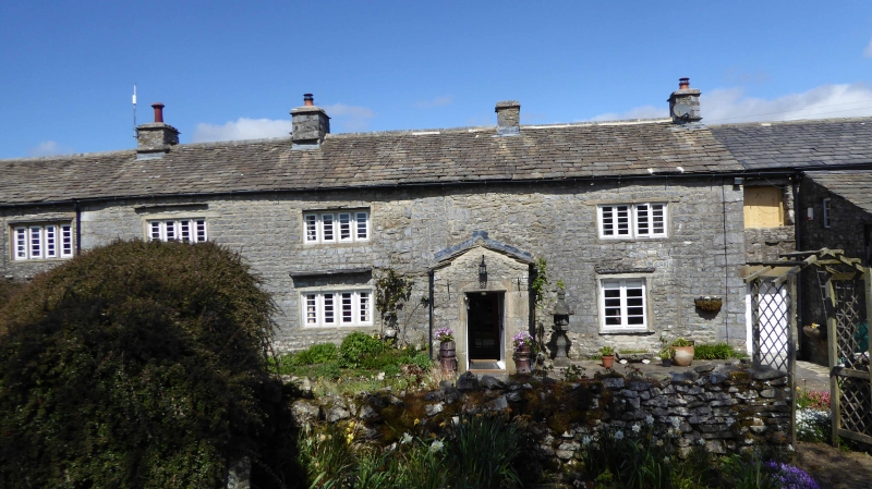
HORTON IN RIBBLESDALE SELSIDE SD 77 NE 7/6 Top Farmhouse 20.2.58 - II Farmhouse. Late C17 with C18 and C20 alterations. Slobbered, squared rubble, stone dressings, stone slate roof. 3 cell plan, 2 storeys, 3 bays. Right of centre entrance in later gabled porch, chamfered surround, lintel inscribed IH 1726, plank door. To left 3 and 4 light ground floor chamfered mullioned windows and two 4-light windows to upper floor; slate dripstones. To right is large C20 ground floor window reusing C18 surrounds; remains of blocked window to right. Upper floor former 4-light chamfered mullioned window, now 2 Lights with only central mullion remaining. Windows have c1980 five pane casements in imitation of former metal casements. 4 ridge stacks, that to right at former right-hand gable, now at junction with outbuilding. Interior: early C18 parlour fireplace with moulded jambs and moulded cornice.
Listing NGR: SD7833675782
External links are from the relevant listing authority and, where applicable, Wikidata. Wikidata IDs may be related buildings as well as this specific building. If you want to add or update a link, you will need to do so by editing the Wikidata entry.


Other nearby listed buildings