Approximate Location Map
Large Map »
Latitude: 51.487 / 51°29'13"N
Longitude: -2.4344 / 2°26'3"W
OS Eastings: 369936
OS Northings: 176541
OS Grid: ST699765
Mapcode National: GBR JY.KGCW
Mapcode Global: VH88J.RWDF
Plus Code: 9C3VFHP8+R7
Entry Name: Unidentified Monument in the Churchyard About One Metre North of North Aisle of Anglican Church of St Thomas À Becket
Listing Date: 15 August 1985
Last Amended: 20 January 2011
Grade: II
Source: Historic England
Source ID: 1212885
English Heritage Legacy ID: 397417
ID on this website: 101212885
Location: St Thomas a Becket's Church, Pucklechurch, South Gloucestershire, BS16
County: South Gloucestershire
Civil Parish: Pucklechurch
Built-Up Area: Pucklechurch
Traditional County: Gloucestershire
Lieutenancy Area (Ceremonial County): Gloucestershire
Church of England Parish: Pucklechurch and Abson
Church of England Diocese: Bristol
Tagged with: Architectural structure
PUCKLECHURCH
1096/4/217 WESTERLEIGH ROAD
15-AUG-85 (East side)
UNIDENTIFIED MONUMENT IN THE CHURCHYAR
D ABOUT ONE METRE NORTH OF NORTH AISLE
OF ANGLICAN CHURCH OF ST THOMAS À BEC
KET
(Formerly listed as:
WESTERLEIGH ROAD
UNIDENTIFIED MONUMENT IN THE CHURCHYAR
D ABOUT ONE METRE NORTH OF NORTH AISLE
OF CHURCH OF ST THOMAS OF CANTERBURY)
GV II
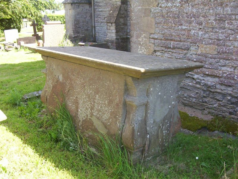
Chest tomb. Early C19, of unknown commemoration. It lies in the churchyard of St Thomas à Beckett, Pucklechurch, about 1 metre to the north of the north aisle of the church. The limestone monument is rectangular on plan and has a flat top with moulded edge, quarter balusters and moulded plinth. On the north and south sides there are inscription panels with a central moulded division but all the inscriptions have eroded away.
HISTORY: Pucklechurch, which appears from the archaeological evidence to have Roman origins, was an important settlement from the later Anglo-Saxon period, when it became the administrative, military and judicial centre of the Hundred which bears its name. The settlement, once forming parts of the ancient Forest of Kingswood, may have been a royal burh in the later Saxon period. Certainly it was the site of Edmund, King of Wessex's hunting lodge; he was murdered in Pucklechurch in AD946, and his body taken to Glastonbury Abbey for burial. The manor of Pucklechurch was formally granted to Glastonbury Abbey in AD950, and was subsequently transferred to Bath Abbey in the C13. After the Dissolution in the C16, the village underwent a phase of rebuilding and gentrification, with a number of large houses erected in the C16, C17 and C18, indicating that the settlement was relatively wealthy in this period. A further phase of expansion and prosperity occurred from the mid-C19, when a number of collieries opened in the parish.
The parish church was founded in the Norman period, and was perhaps a royal foundation, but the current building dates largely from the C13; a north aisle and south porch were built in the C14, together with parts of the tower. A chantry, now the site of the Lady Chapel, was set up by William de Cheltenham in 1337. There were further alterations in the C17, coinciding with the increased prosperity of the settlement after the Dissolution, and there were two major phases of work in the C19, the first, by R C Carpenter, in 1846-56, and the second, by J D Sedding, in 1889. These included some reordering, and the replacement of some windows, the introduction of new fittings, and some stained glass. There has been some further, minor refitting in the C20.
REASONS FOR DESIGNATION: The chest tomb of unknown dedication is designated at Grade II for the following principal reasons:
* Architectural: as a good example of an early-C19 chest tomb
* Group value: for its relationship with the Grade I listed church of St Thomas à Becket, and with other listed tombs.
External links are from the relevant listing authority and, where applicable, Wikidata. Wikidata IDs may be related buildings as well as this specific building. If you want to add or update a link, you will need to do so by editing the Wikidata entry.


Other nearby listed buildings
