Approximate Location Map
Large Map »
Latitude: 51.3327 / 51°19'57"N
Longitude: -0.2708 / 0°16'14"W
OS Eastings: 520565
OS Northings: 160708
OS Grid: TQ205607
Mapcode National: GBR 93.VSW
Mapcode Global: VHGRP.8R6Q
Plus Code: 9C3X8PMH+3M
Entry Name: The Albion Public House
Listing Date: 22 March 1974
Grade: II
Source: Historic England
Source ID: 1213295
English Heritage Legacy ID: 397866
ID on this website: 101213295
Location: Epsom, Epsom and Ewell, Surrey, KT18
County: Surrey
District: Epsom and Ewell
Electoral Ward/Division: Town
Parish: Non Civil Parish
Built-Up Area: Epsom
Traditional County: Surrey
Lieutenancy Area (Ceremonial County): Surrey
Church of England Parish: Epsom Common Christ Church
Church of England Diocese: Guildford
Tagged with: Pub
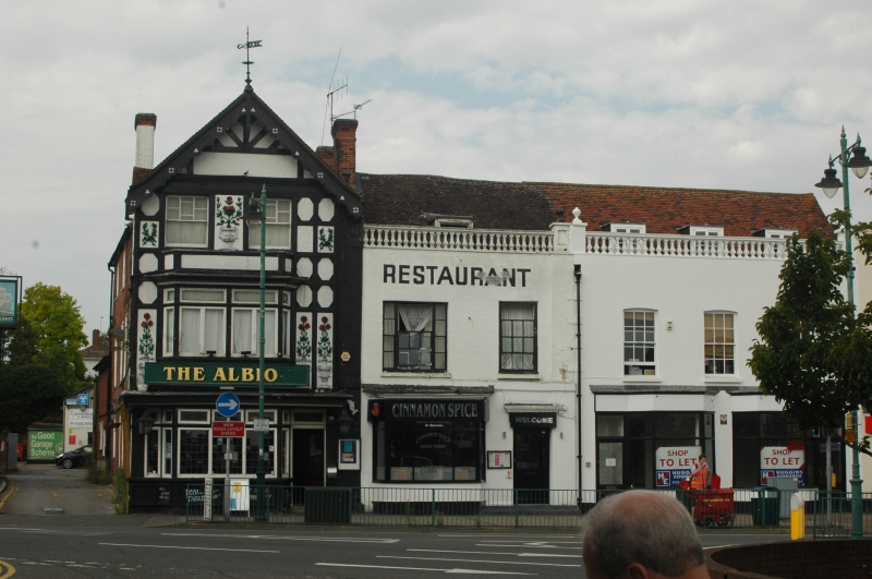
TQ 2060 EPSOM HIGH STREET
(West side)
861/30/328
No.134
The Albion Public House
GV II
Early C18. Three storeys, red brick, bands, sashes, old tile roof. Front, Edwardian timber framing and roughcast. Elaborate pargetting and barge-boards.
Nos.126-134 (even) form a group with Nos.1-15 (odd) West Street.
Listing NGR: TQ2056560708
External links are from the relevant listing authority and, where applicable, Wikidata. Wikidata IDs may be related buildings as well as this specific building. If you want to add or update a link, you will need to do so by editing the Wikidata entry.


Other nearby listed buildings
