Approximate Location Map
Large Map »
Latitude: 50.7435 / 50°44'36"N
Longitude: -2.7321 / 2°43'55"W
OS Eastings: 348442
OS Northings: 94017
OS Grid: SY484940
Mapcode National: GBR PQ.4L3G
Mapcode Global: FRA 5753.TNZ
Plus Code: 9C2VP7V9+95
Entry Name: Stepps Farmhouse
Listing Date: 7 August 1952
Grade: II
Source: Historic England
Source ID: 1213872
English Heritage Legacy ID: 398526
ID on this website: 101213872
Location: Bradpole, Dorset, DT6
County: Dorset
Civil Parish: Bradpole
Traditional County: Dorset
Lieutenancy Area (Ceremonial County): Dorset
Church of England Parish: Bridport St Mary
Church of England Diocese: Salisbury
Tagged with: Farmhouse Thatched farmhouse
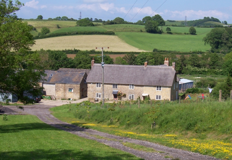
SY 49 SE BRADPOLE STEPPS FARM
2/62 Stepps Farmhouse
7-8-52
- II
Detached Farmhouse. c.Late C18. Rubble stone walls, rendered at
right hand end. Thatch roof, half-hipped at left hand. 2 storeys.
4 windows, 3-light wooden casements with lead lights. Front door,
right of centre, wood with glass lights, C20.
RCHM Dorset I, p 37(7)
Listing NGR: SY4844294017
External links are from the relevant listing authority and, where applicable, Wikidata. Wikidata IDs may be related buildings as well as this specific building. If you want to add or update a link, you will need to do so by editing the Wikidata entry.


Other nearby listed buildings
